You are here: Home > Network List > US - United States National Seismic Network Stations List
> Station MNTX Cornudas Mountains, Texas, USA > Earthquake Result Viewer
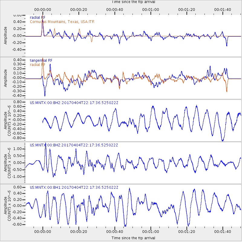
MNTX Cornudas Mountains, Texas, USA - Earthquake Result Viewer
*The percent match for this event was below the threshold and hence no stack was calculated.
| Earthquake location: |
Andreanof Islands, Aleutian Is. |
| Earthquake latitude/longitude: |
51.3/-176.4 |
| Earthquake time(UTC): |
2017/04/04 (094) 22:08:40 GMT |
| Earthquake Depth: |
13 km |
| Earthquake Magnitude: |
5.5 Mww |
| Earthquake Catalog/Contributor: |
NEIC PDE/us |
|
| Network: |
US United States National Seismic Network |
| Station: |
MNTX Cornudas Mountains, Texas, USA |
| Lat/Lon: |
31.70 N/105.38 W |
| Elevation: |
404 m |
|
| Distance: |
54.5 deg |
| Az: |
82.006 deg |
| Baz: |
313.127 deg |
| Ray Param: |
$rayparam |
*The percent match for this event was below the threshold and hence was not used in the summary stack. |
|
| Radial Match: |
55.46814 % |
| Radial Bump: |
400 |
| Transverse Match: |
49.136124 % |
| Transverse Bump: |
400 |
| SOD ConfigId: |
2140511 |
| Insert Time: |
2017-06-12 21:51:47.696 +0000 |
| GWidth: |
2.5 |
| Max Bumps: |
400 |
| Tol: |
0.001 |
|
Signal To Noise
| Channel | StoN | STA | LTA |
| US:MNTX:00:BHZ:20170404T22:17:36.525022Z | 3.7717643 | 6.2122507E-7 | 1.647041E-7 |
| US:MNTX:00:BH1:20170404T22:17:36.525022Z | 1.4812044 | 2.9818332E-7 | 2.0131141E-7 |
| US:MNTX:00:BH2:20170404T22:17:36.525022Z | 0.83371806 | 1.7247311E-7 | 2.0687222E-7 |
| Arrivals |
| Ps | |
| PpPs | |
| PsPs/PpSs | |


