You are here: Home > Network List > TA - USArray Transportable Network (new EarthScope stations) Stations List
> Station A19K Wainwright, AK, USA > Earthquake Result Viewer
A19K Wainwright, AK, USA - Earthquake Result Viewer
| Earthquake location: |
Near East Coast Of Honshu, Japan |
| Earthquake latitude/longitude: |
36.4/141.1 |
| Earthquake time(UTC): |
2020/05/10 (131) 23:58:33 GMT |
| Earthquake Depth: |
30 km |
| Earthquake Magnitude: |
5.8 Mww |
| Earthquake Catalog/Contributor: |
NEIC PDE/us |
|
| Network: |
TA USArray Transportable Network (new EarthScope stations) |
| Station: |
A19K Wainwright, AK, USA |
| Lat/Lon: |
70.20 N/161.07 W |
| Elevation: |
24 m |
|
| Distance: |
45.4 deg |
| Az: |
23.876 deg |
| Baz: |
253.435 deg |
| Ray Param: |
0.07124392 |
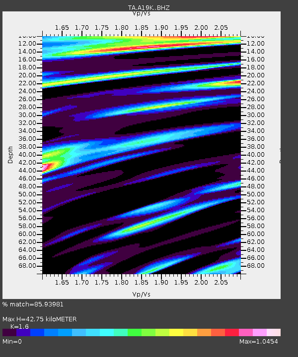
| Estimated Moho Depth: |
42.75 km |
| Estimated Crust Vp/Vs: |
1.60 |
| Assumed Crust Vp: |
5.989 km/s |
| Estimated Crust Vs: |
3.743 km/s |
| Estimated Crust Poisson's Ratio: |
0.18 |
|
| Radial Match: |
85.93981 % |
| Radial Bump: |
400 |
| Transverse Match: |
73.77667 % |
| Transverse Bump: |
400 |
| SOD ConfigId: |
21166931 |
| Insert Time: |
2020-05-25 00:15:04.769 +0000 |
| GWidth: |
2.5 |
| Max Bumps: |
400 |
| Tol: |
0.001 |
|

Signal To Noise
| Channel | StoN | STA | LTA |
| TA:A19K: :BHZ:20200511T00:06:18.949987Z | 4.934319 | 6.4884307E-7 | 1.3149597E-7 |
| TA:A19K: :BHN:20200511T00:06:18.949987Z | 1.3306822 | 1.2373204E-7 | 9.298391E-8 |
| TA:A19K: :BHE:20200511T00:06:18.949987Z | 2.3508847 | 2.2365958E-7 | 9.5138475E-8 |
| Arrivals |
| Ps | 4.6 SECOND |
| PpPs | 17 SECOND |
| PsPs/PpSs | 22 SECOND |


