You are here: Home > Network List > TA - USArray Transportable Network (new EarthScope stations) Stations List
> Station B22K Teshekpuk Lake, AK, USA > Earthquake Result Viewer
B22K Teshekpuk Lake, AK, USA - Earthquake Result Viewer
| Earthquake location: |
Near East Coast Of Honshu, Japan |
| Earthquake latitude/longitude: |
36.4/141.1 |
| Earthquake time(UTC): |
2020/05/10 (131) 23:58:33 GMT |
| Earthquake Depth: |
30 km |
| Earthquake Magnitude: |
5.8 Mww |
| Earthquake Catalog/Contributor: |
NEIC PDE/us |
|
| Network: |
TA USArray Transportable Network (new EarthScope stations) |
| Station: |
B22K Teshekpuk Lake, AK, USA |
| Lat/Lon: |
70.34 N/153.42 W |
| Elevation: |
50 m |
|
| Distance: |
48.0 deg |
| Az: |
24.482 deg |
| Baz: |
261.049 deg |
| Ray Param: |
0.069613814 |
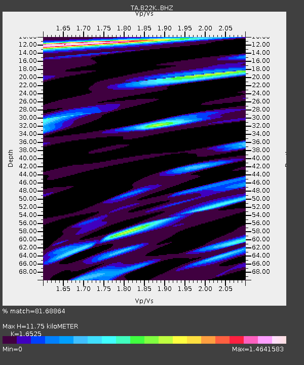
| Estimated Moho Depth: |
11.75 km |
| Estimated Crust Vp/Vs: |
1.65 |
| Assumed Crust Vp: |
5.738 km/s |
| Estimated Crust Vs: |
3.472 km/s |
| Estimated Crust Poisson's Ratio: |
0.21 |
|
| Radial Match: |
81.68864 % |
| Radial Bump: |
400 |
| Transverse Match: |
68.35564 % |
| Transverse Bump: |
400 |
| SOD ConfigId: |
21166931 |
| Insert Time: |
2020-05-25 00:15:10.718 +0000 |
| GWidth: |
2.5 |
| Max Bumps: |
400 |
| Tol: |
0.001 |
|

Signal To Noise
| Channel | StoN | STA | LTA |
| TA:B22K: :BHZ:20200511T00:06:38.975011Z | 9.08566 | 9.948969E-7 | 1.0950189E-7 |
| TA:B22K: :BHN:20200511T00:06:38.975011Z | 1.5013338 | 2.2345137E-7 | 1.4883523E-7 |
| TA:B22K: :BHE:20200511T00:06:38.975011Z | 1.4733216 | 3.780983E-7 | 2.5662985E-7 |
| Arrivals |
| Ps | 1.4 SECOND |
| PpPs | 5.2 SECOND |
| PsPs/PpSs | 6.6 SECOND |


