You are here: Home > Network List > TA - USArray Transportable Network (new EarthScope stations) Stations List
> Station E20K Nigu River, AK, USA > Earthquake Result Viewer
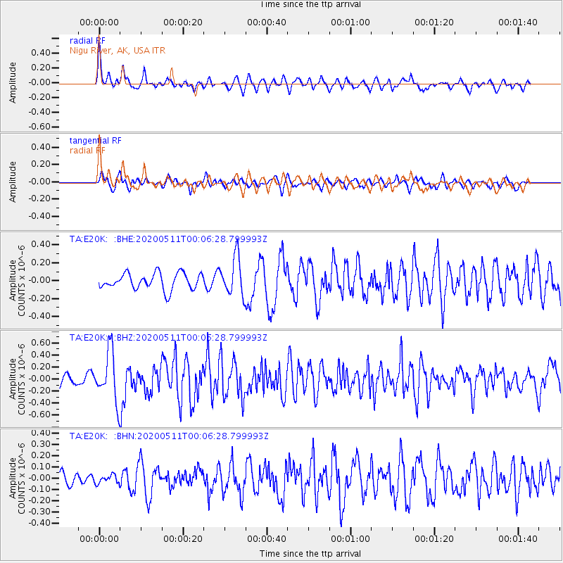
E20K Nigu River, AK, USA - Earthquake Result Viewer
*The percent match for this event was below the threshold and hence no stack was calculated.
| Earthquake location: |
Near East Coast Of Honshu, Japan |
| Earthquake latitude/longitude: |
36.4/141.1 |
| Earthquake time(UTC): |
2020/05/10 (131) 23:58:33 GMT |
| Earthquake Depth: |
30 km |
| Earthquake Magnitude: |
5.8 Mww |
| Earthquake Catalog/Contributor: |
NEIC PDE/us |
|
| Network: |
TA USArray Transportable Network (new EarthScope stations) |
| Station: |
E20K Nigu River, AK, USA |
| Lat/Lon: |
68.26 N/156.19 W |
| Elevation: |
866 m |
|
| Distance: |
46.7 deg |
| Az: |
27.072 deg |
| Baz: |
260.217 deg |
| Ray Param: |
$rayparam |
*The percent match for this event was below the threshold and hence was not used in the summary stack. |
|
| Radial Match: |
77.93849 % |
| Radial Bump: |
400 |
| Transverse Match: |
74.45317 % |
| Transverse Bump: |
400 |
| SOD ConfigId: |
21166931 |
| Insert Time: |
2020-05-25 00:15:41.977 +0000 |
| GWidth: |
2.5 |
| Max Bumps: |
400 |
| Tol: |
0.001 |
|
Signal To Noise
| Channel | StoN | STA | LTA |
| TA:E20K: :BHZ:20200511T00:06:28.799993Z | 5.554213 | 4.271592E-7 | 7.690724E-8 |
| TA:E20K: :BHN:20200511T00:06:28.799993Z | 0.5812452 | 3.7350816E-8 | 6.426E-8 |
| TA:E20K: :BHE:20200511T00:06:28.799993Z | 2.4270463 | 2.1875618E-7 | 9.013268E-8 |
| Arrivals |
| Ps | |
| PpPs | |
| PsPs/PpSs | |


