You are here: Home > Network List > TA - USArray Transportable Network (new EarthScope stations) Stations List
> Station F14K Arctic Creek, AK, USA > Earthquake Result Viewer
F14K Arctic Creek, AK, USA - Earthquake Result Viewer
| Earthquake location: |
Near East Coast Of Honshu, Japan |
| Earthquake latitude/longitude: |
36.4/141.1 |
| Earthquake time(UTC): |
2020/05/10 (131) 23:58:33 GMT |
| Earthquake Depth: |
30 km |
| Earthquake Magnitude: |
5.8 Mww |
| Earthquake Catalog/Contributor: |
NEIC PDE/us |
|
| Network: |
TA USArray Transportable Network (new EarthScope stations) |
| Station: |
F14K Arctic Creek, AK, USA |
| Lat/Lon: |
65.47 N/166.33 W |
| Elevation: |
266 m |
|
| Distance: |
42.1 deg |
| Az: |
29.604 deg |
| Baz: |
252.706 deg |
| Ray Param: |
0.07331661 |
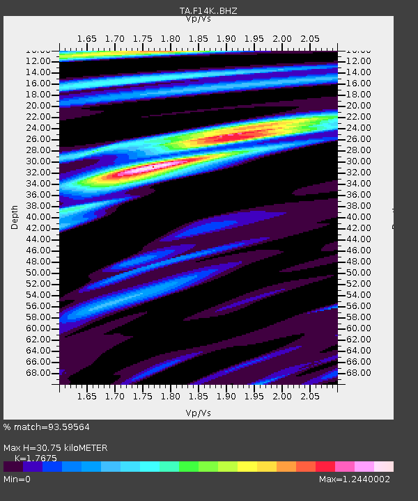
| Estimated Moho Depth: |
30.75 km |
| Estimated Crust Vp/Vs: |
1.77 |
| Assumed Crust Vp: |
6.307 km/s |
| Estimated Crust Vs: |
3.568 km/s |
| Estimated Crust Poisson's Ratio: |
0.26 |
|
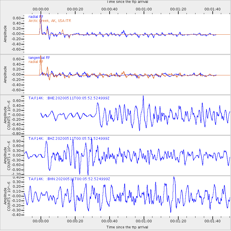
| Radial Match: |
93.59564 % |
| Radial Bump: |
313 |
| Transverse Match: |
71.01719 % |
| Transverse Bump: |
400 |
| SOD ConfigId: |
21166931 |
| Insert Time: |
2020-05-25 00:15:55.186 +0000 |
| GWidth: |
2.5 |
| Max Bumps: |
400 |
| Tol: |
0.001 |
|
Signal To Noise
| Channel | StoN | STA | LTA |
| TA:F14K: :BHZ:20200511T00:05:52.524999Z | 2.664998 | 4.3605175E-7 | 1.6362179E-7 |
| TA:F14K: :BHN:20200511T00:05:52.524999Z | 0.7277789 | 6.650465E-8 | 9.1380294E-8 |
| TA:F14K: :BHE:20200511T00:05:52.524999Z | 2.8396976 | 2.4246876E-7 | 8.5385416E-8 |
| Arrivals |
| Ps | 4.0 SECOND |
| PpPs | 13 SECOND |
| PsPs/PpSs | 17 SECOND |


