You are here: Home > Network List > TA - USArray Transportable Network (new EarthScope stations) Stations List
> Station F26K Sheenjek River, AK, USA > Earthquake Result Viewer
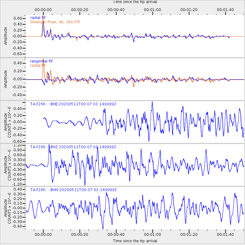
F26K Sheenjek River, AK, USA - Earthquake Result Viewer
*The percent match for this event was below the threshold and hence no stack was calculated.
| Earthquake location: |
Near East Coast Of Honshu, Japan |
| Earthquake latitude/longitude: |
36.4/141.1 |
| Earthquake time(UTC): |
2020/05/10 (131) 23:58:33 GMT |
| Earthquake Depth: |
30 km |
| Earthquake Magnitude: |
5.8 Mww |
| Earthquake Catalog/Contributor: |
NEIC PDE/us |
|
| Network: |
TA USArray Transportable Network (new EarthScope stations) |
| Station: |
F26K Sheenjek River, AK, USA |
| Lat/Lon: |
67.69 N/144.15 W |
| Elevation: |
683 m |
|
| Distance: |
51.1 deg |
| Az: |
28.218 deg |
| Baz: |
272.13 deg |
| Ray Param: |
$rayparam |
*The percent match for this event was below the threshold and hence was not used in the summary stack. |
|
| Radial Match: |
77.93543 % |
| Radial Bump: |
400 |
| Transverse Match: |
66.0125 % |
| Transverse Bump: |
400 |
| SOD ConfigId: |
21166931 |
| Insert Time: |
2020-05-25 00:16:09.112 +0000 |
| GWidth: |
2.5 |
| Max Bumps: |
400 |
| Tol: |
0.001 |
|
Signal To Noise
| Channel | StoN | STA | LTA |
| TA:F26K: :BHZ:20200511T00:07:03.149999Z | 4.1090603 | 4.812415E-7 | 1.1711717E-7 |
| TA:F26K: :BHN:20200511T00:07:03.149999Z | 0.6490909 | 5.890409E-8 | 9.07486E-8 |
| TA:F26K: :BHE:20200511T00:07:03.149999Z | 2.5150175 | 1.7316813E-7 | 6.885365E-8 |
| Arrivals |
| Ps | |
| PpPs | |
| PsPs/PpSs | |


