You are here: Home > Network List > AK - Alaska Regional Network Stations List
> Station I21K Tanana, AK, USA > Earthquake Result Viewer
I21K Tanana, AK, USA - Earthquake Result Viewer
| Earthquake location: |
Santa Cruz Islands |
| Earthquake latitude/longitude: |
-12.1/166.6 |
| Earthquake time(UTC): |
2020/05/12 (133) 22:41:12 GMT |
| Earthquake Depth: |
107 km |
| Earthquake Magnitude: |
6.6 mww |
| Earthquake Catalog/Contributor: |
NEIC PDE/us |
|
| Network: |
AK Alaska Regional Network |
| Station: |
I21K Tanana, AK, USA |
| Lat/Lon: |
65.18 N/151.98 W |
| Elevation: |
248 m |
|
| Distance: |
83.0 deg |
| Az: |
16.323 deg |
| Baz: |
220.642 deg |
| Ray Param: |
0.04625333 |
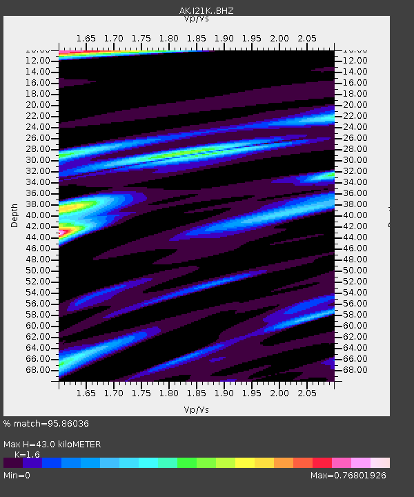
| Estimated Moho Depth: |
43.0 km |
| Estimated Crust Vp/Vs: |
1.60 |
| Assumed Crust Vp: |
6.566 km/s |
| Estimated Crust Vs: |
4.104 km/s |
| Estimated Crust Poisson's Ratio: |
0.18 |
|
| Radial Match: |
95.86036 % |
| Radial Bump: |
400 |
| Transverse Match: |
92.10971 % |
| Transverse Bump: |
400 |
| SOD ConfigId: |
21166931 |
| Insert Time: |
2020-05-26 22:43:08.290 +0000 |
| GWidth: |
2.5 |
| Max Bumps: |
400 |
| Tol: |
0.001 |
|

Signal To Noise
| Channel | StoN | STA | LTA |
| AK:I21K: :BHZ:20200512T22:52:54.499021Z | 45.023453 | 3.0463914E-6 | 6.766232E-8 |
| AK:I21K: :BHN:20200512T22:52:54.499021Z | 16.87792 | 1.0547526E-6 | 6.2493044E-8 |
| AK:I21K: :BHE:20200512T22:52:54.499021Z | 8.096155 | 6.349083E-7 | 7.842096E-8 |
| Arrivals |
| Ps | 4.0 SECOND |
| PpPs | 17 SECOND |
| PsPs/PpSs | 21 SECOND |


