You are here: Home > Network List > TX - Texas Seismological Network Stations List
> Station WTFS Witchita Falls > Earthquake Result Viewer
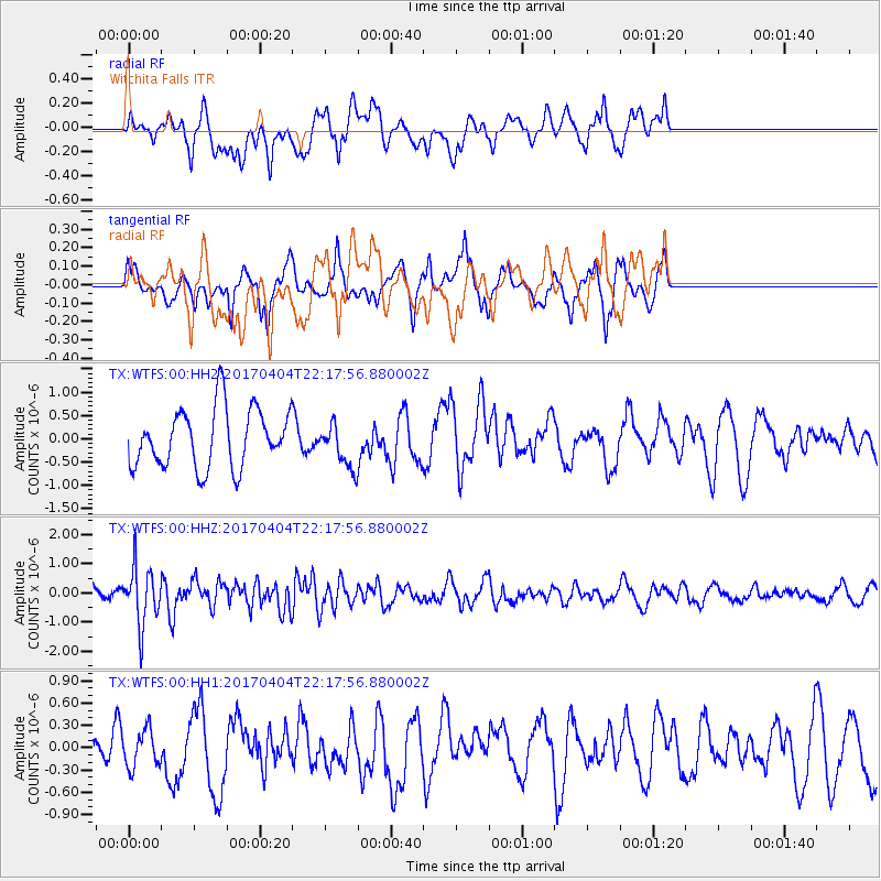
WTFS Witchita Falls - Earthquake Result Viewer
*The percent match for this event was below the threshold and hence no stack was calculated.
| Earthquake location: |
Andreanof Islands, Aleutian Is. |
| Earthquake latitude/longitude: |
51.3/-176.4 |
| Earthquake time(UTC): |
2017/04/04 (094) 22:08:40 GMT |
| Earthquake Depth: |
13 km |
| Earthquake Magnitude: |
5.5 Mww |
| Earthquake Catalog/Contributor: |
NEIC PDE/us |
|
| Network: |
TX Texas Seismological Network |
| Station: |
WTFS Witchita Falls |
| Lat/Lon: |
33.77 N/98.46 W |
| Elevation: |
277 m |
|
| Distance: |
57.4 deg |
| Az: |
75.38 deg |
| Baz: |
313.137 deg |
| Ray Param: |
$rayparam |
*The percent match for this event was below the threshold and hence was not used in the summary stack. |
|
| Radial Match: |
51.409702 % |
| Radial Bump: |
400 |
| Transverse Match: |
53.9943 % |
| Transverse Bump: |
400 |
| SOD ConfigId: |
2140511 |
| Insert Time: |
2017-06-12 21:55:17.781 +0000 |
| GWidth: |
2.5 |
| Max Bumps: |
400 |
| Tol: |
0.001 |
|
Signal To Noise
| Channel | StoN | STA | LTA |
| TX:WTFS:00:HHZ:20170404T22:17:56.880002Z | 3.679744 | 9.823641E-7 | 2.6696534E-7 |
| TX:WTFS:00:HH1:20170404T22:17:56.880002Z | 0.5700163 | 2.492473E-7 | 4.3726345E-7 |
| TX:WTFS:00:HH2:20170404T22:17:56.880002Z | 0.74060863 | 4.6212617E-7 | 6.2398163E-7 |
| Arrivals |
| Ps | |
| PpPs | |
| PsPs/PpSs | |


