You are here: Home > Network List > AK - Alaska Regional Network Stations List
> Station MDM Murphy Dome > Earthquake Result Viewer
MDM Murphy Dome - Earthquake Result Viewer
| Earthquake location: |
Santa Cruz Islands |
| Earthquake latitude/longitude: |
-12.1/166.6 |
| Earthquake time(UTC): |
2020/05/12 (133) 22:41:12 GMT |
| Earthquake Depth: |
107 km |
| Earthquake Magnitude: |
6.6 mww |
| Earthquake Catalog/Contributor: |
NEIC PDE/us |
|
| Network: |
AK Alaska Regional Network |
| Station: |
MDM Murphy Dome |
| Lat/Lon: |
64.96 N/148.23 W |
| Elevation: |
634 m |
|
| Distance: |
83.9 deg |
| Az: |
17.656 deg |
| Baz: |
224.193 deg |
| Ray Param: |
0.045613296 |
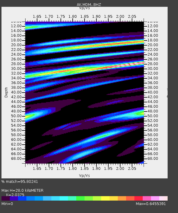
| Estimated Moho Depth: |
28.0 km |
| Estimated Crust Vp/Vs: |
2.04 |
| Assumed Crust Vp: |
6.566 km/s |
| Estimated Crust Vs: |
3.223 km/s |
| Estimated Crust Poisson's Ratio: |
0.34 |
|
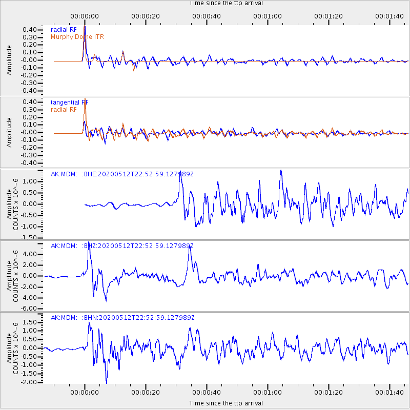
| Radial Match: |
95.80241 % |
| Radial Bump: |
400 |
| Transverse Match: |
88.33719 % |
| Transverse Bump: |
400 |
| SOD ConfigId: |
21166931 |
| Insert Time: |
2020-05-26 22:43:45.896 +0000 |
| GWidth: |
2.5 |
| Max Bumps: |
400 |
| Tol: |
0.001 |
|
Signal To Noise
| Channel | StoN | STA | LTA |
| AK:MDM: :BHZ:20200512T22:52:59.127989Z | 26.32699 | 2.6320533E-6 | 9.997547E-8 |
| AK:MDM: :BHN:20200512T22:52:59.127989Z | 14.003402 | 7.6311244E-7 | 5.449479E-8 |
| AK:MDM: :BHE:20200512T22:52:59.127989Z | 11.402177 | 6.4819034E-7 | 5.6847945E-8 |
| Arrivals |
| Ps | 4.5 SECOND |
| PpPs | 13 SECOND |
| PsPs/PpSs | 17 SECOND |


