You are here: Home > Network List > AK - Alaska Regional Network Stations List
> Station O18K Koktuh Hills, AK, USA > Earthquake Result Viewer
O18K Koktuh Hills, AK, USA - Earthquake Result Viewer
| Earthquake location: |
Santa Cruz Islands |
| Earthquake latitude/longitude: |
-12.1/166.6 |
| Earthquake time(UTC): |
2020/05/12 (133) 22:41:12 GMT |
| Earthquake Depth: |
107 km |
| Earthquake Magnitude: |
6.6 mww |
| Earthquake Catalog/Contributor: |
NEIC PDE/us |
|
| Network: |
AK Alaska Regional Network |
| Station: |
O18K Koktuh Hills, AK, USA |
| Lat/Lon: |
59.85 N/155.21 W |
| Elevation: |
544 m |
|
| Distance: |
77.9 deg |
| Az: |
18.589 deg |
| Baz: |
218.156 deg |
| Ray Param: |
0.049742173 |
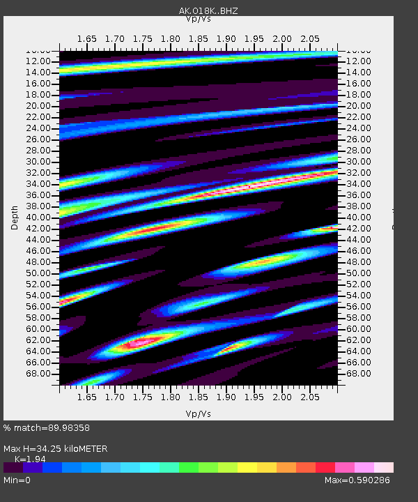
| Estimated Moho Depth: |
34.25 km |
| Estimated Crust Vp/Vs: |
1.94 |
| Assumed Crust Vp: |
6.438 km/s |
| Estimated Crust Vs: |
3.319 km/s |
| Estimated Crust Poisson's Ratio: |
0.32 |
|
| Radial Match: |
89.98358 % |
| Radial Bump: |
400 |
| Transverse Match: |
75.57941 % |
| Transverse Bump: |
400 |
| SOD ConfigId: |
21166931 |
| Insert Time: |
2020-05-26 22:43:54.890 +0000 |
| GWidth: |
2.5 |
| Max Bumps: |
400 |
| Tol: |
0.001 |
|

Signal To Noise
| Channel | StoN | STA | LTA |
| AK:O18K: :BHZ:20200512T22:52:27.46002Z | 20.497612 | 2.0577013E-6 | 1.0038737E-7 |
| AK:O18K: :BHN:20200512T22:52:27.46002Z | 13.310163 | 7.4889545E-7 | 5.6264938E-8 |
| AK:O18K: :BHE:20200512T22:52:27.46002Z | 3.9466813 | 4.158519E-7 | 1.05367484E-7 |
| Arrivals |
| Ps | 5.1 SECOND |
| PpPs | 15 SECOND |
| PsPs/PpSs | 20 SECOND |


