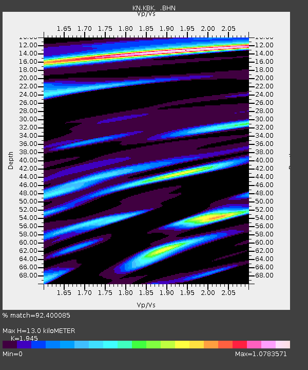
KBK KN.KBK - Earthquake Result Viewer
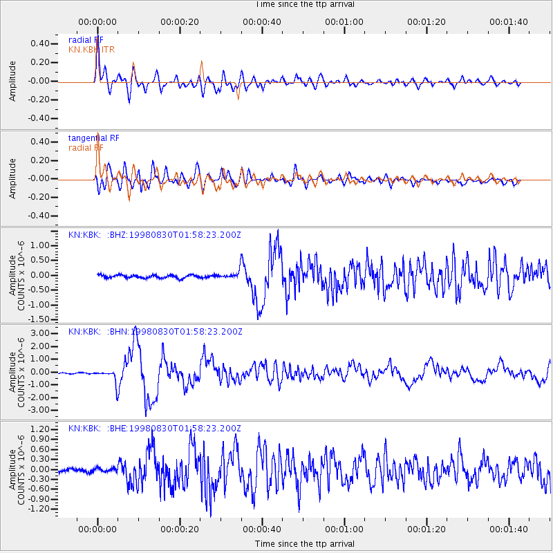
Earthquake location: Mariana Islands Region
Earthquake latitude/longitude: 17.1/148.1
Earthquake time(UTC): 1998/08/30 (242) 01:48:08 GMT
Earthquake Depth: 33 km
Earthquake Magnitude: 6.0 MB, 6.1 MS, 6.2 UNKNOWN, 5.9 ME
Earthquake Catalog/Contributor: WHDF/NEIC
Network: KN Kyrgyz Seismic Telemetry Network
Station: KBK KN.KBK
Lat/Lon: 42.66 N/74.95 E
Elevation: 1760 m
Distance: 66.3 deg
Az: 309.56 deg
Baz: 88.204 deg
Ray Param: 0.05762819
Estimated Moho Depth: 13.0 km
Estimated Crust Vp/Vs: 1.95
Assumed Crust Vp: 6.306 km/s
Estimated Crust Vs: 3.242 km/s
Estimated Crust Poisson's Ratio: 0.32
Radial Match: 92.400085 %
Radial Bump: 400
Transverse Match: 85.64149 %
Transverse Bump: 400
SOD ConfigId: 4480
Insert Time: 2010-03-08 19:59:52.420 +0000
GWidth: 2.5
Max Bumps: 400
Tol: 0.001

Signal To Noise

ChannelStoNSTALTA
KN:KBK: :BHN:19980830T01:58:23.200Z11.2016385.2901066E-74.7226187E-8
KN:KBK: :BHE:19980830T01:58:23.200Z1.18939985.9221204E-84.9790827E-8
KN:KBK: :BHZ:19980830T01:58:23.200Z2.792461.4370477E-75.1461708E-8
Arrivals
Ps2.0 SECOND
PpPs5.9 SECOND
PsPs/PpSs7.9 SECOND