You are here: Home > Network List > AK - Alaska Regional Network Stations List
> Station SKN Skwentna > Earthquake Result Viewer
SKN Skwentna - Earthquake Result Viewer
| Earthquake location: |
Santa Cruz Islands |
| Earthquake latitude/longitude: |
-12.1/166.6 |
| Earthquake time(UTC): |
2020/05/12 (133) 22:41:12 GMT |
| Earthquake Depth: |
107 km |
| Earthquake Magnitude: |
6.6 mww |
| Earthquake Catalog/Contributor: |
NEIC PDE/us |
|
| Network: |
AK Alaska Regional Network |
| Station: |
SKN Skwentna |
| Lat/Lon: |
61.98 N/151.53 W |
| Elevation: |
603 m |
|
| Distance: |
80.7 deg |
| Az: |
18.607 deg |
| Baz: |
221.37 deg |
| Ray Param: |
0.04784714 |
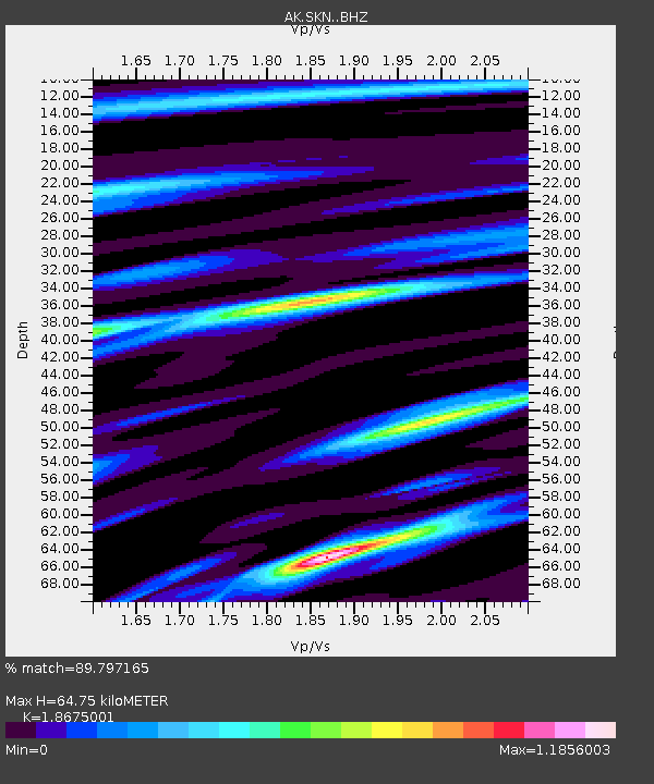
| Estimated Moho Depth: |
64.75 km |
| Estimated Crust Vp/Vs: |
1.87 |
| Assumed Crust Vp: |
6.302 km/s |
| Estimated Crust Vs: |
3.374 km/s |
| Estimated Crust Poisson's Ratio: |
0.30 |
|
| Radial Match: |
89.797165 % |
| Radial Bump: |
400 |
| Transverse Match: |
83.73678 % |
| Transverse Bump: |
400 |
| SOD ConfigId: |
21166931 |
| Insert Time: |
2020-05-26 22:44:32.202 +0000 |
| GWidth: |
2.5 |
| Max Bumps: |
400 |
| Tol: |
0.001 |
|

Signal To Noise
| Channel | StoN | STA | LTA |
| AK:SKN: :BHZ:20200512T22:52:42.547972Z | 20.94872 | 1.7258349E-6 | 8.238378E-8 |
| AK:SKN: :BHN:20200512T22:52:42.547972Z | 6.3906937 | 4.647873E-7 | 7.2728774E-8 |
| AK:SKN: :BHE:20200512T22:52:42.547972Z | 3.8430753 | 4.0124553E-7 | 1.04407405E-7 |
| Arrivals |
| Ps | 9.1 SECOND |
| PpPs | 29 SECOND |
| PsPs/PpSs | 38 SECOND |


