You are here: Home > Network List > AK - Alaska Regional Network Stations List
> Station WRH Wood River Hill > Earthquake Result Viewer
WRH Wood River Hill - Earthquake Result Viewer
| Earthquake location: |
Santa Cruz Islands |
| Earthquake latitude/longitude: |
-12.1/166.6 |
| Earthquake time(UTC): |
2020/05/12 (133) 22:41:12 GMT |
| Earthquake Depth: |
107 km |
| Earthquake Magnitude: |
6.6 mww |
| Earthquake Catalog/Contributor: |
NEIC PDE/us |
|
| Network: |
AK Alaska Regional Network |
| Station: |
WRH Wood River Hill |
| Lat/Lon: |
64.47 N/148.09 W |
| Elevation: |
343 m |
|
| Distance: |
83.6 deg |
| Az: |
18.042 deg |
| Baz: |
224.361 deg |
| Ray Param: |
0.045824893 |
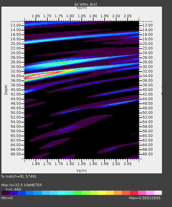
| Estimated Moho Depth: |
33.5 km |
| Estimated Crust Vp/Vs: |
1.66 |
| Assumed Crust Vp: |
6.566 km/s |
| Estimated Crust Vs: |
3.944 km/s |
| Estimated Crust Poisson's Ratio: |
0.22 |
|
| Radial Match: |
91.57491 % |
| Radial Bump: |
400 |
| Transverse Match: |
88.71923 % |
| Transverse Bump: |
400 |
| SOD ConfigId: |
21166931 |
| Insert Time: |
2020-05-26 22:44:52.500 +0000 |
| GWidth: |
2.5 |
| Max Bumps: |
400 |
| Tol: |
0.001 |
|

Signal To Noise
| Channel | StoN | STA | LTA |
| AK:WRH: :BHZ:20200512T22:52:57.567991Z | 27.91174 | 3.1053496E-6 | 1.11256035E-7 |
| AK:WRH: :BHN:20200512T22:52:57.567991Z | 4.956631 | 5.389013E-7 | 1.087233E-7 |
| AK:WRH: :BHE:20200512T22:52:57.567991Z | 7.2204823 | 8.549249E-7 | 1.1840274E-7 |
| Arrivals |
| Ps | 3.5 SECOND |
| PpPs | 13 SECOND |
| PsPs/PpSs | 17 SECOND |


