You are here: Home > Network List > AU - Australian Seismological Centre Stations List
> Station MOO Moorlands, Tasmania > Earthquake Result Viewer
MOO Moorlands, Tasmania - Earthquake Result Viewer
| Earthquake location: |
Santa Cruz Islands |
| Earthquake latitude/longitude: |
-12.1/166.6 |
| Earthquake time(UTC): |
2020/05/12 (133) 22:41:12 GMT |
| Earthquake Depth: |
107 km |
| Earthquake Magnitude: |
6.6 mww |
| Earthquake Catalog/Contributor: |
NEIC PDE/us |
|
| Network: |
AU Australian Seismological Centre |
| Station: |
MOO Moorlands, Tasmania |
| Lat/Lon: |
42.44 S/147.19 E |
| Elevation: |
325 m |
|
| Distance: |
34.7 deg |
| Az: |
205.683 deg |
| Baz: |
34.94 deg |
| Ray Param: |
0.07728155 |
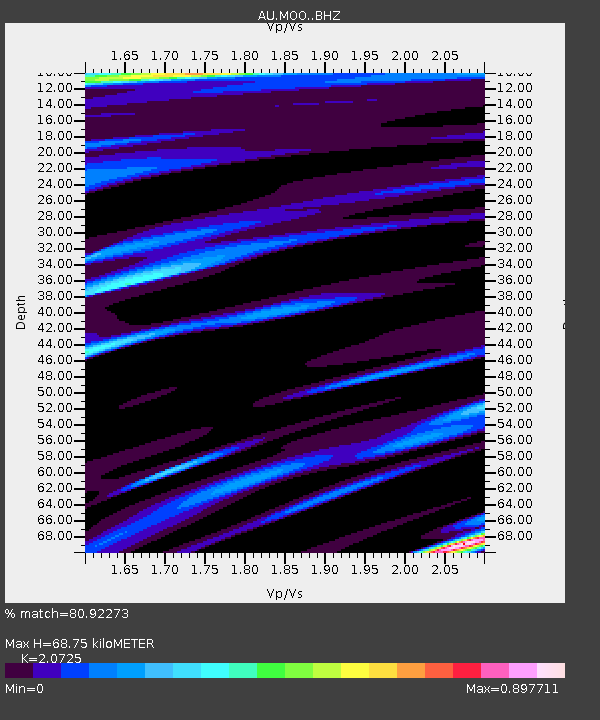
| Estimated Moho Depth: |
68.75 km |
| Estimated Crust Vp/Vs: |
2.07 |
| Assumed Crust Vp: |
6.477 km/s |
| Estimated Crust Vs: |
3.125 km/s |
| Estimated Crust Poisson's Ratio: |
0.35 |
|
| Radial Match: |
80.92273 % |
| Radial Bump: |
400 |
| Transverse Match: |
56.18633 % |
| Transverse Bump: |
400 |
| SOD ConfigId: |
21166931 |
| Insert Time: |
2020-05-26 22:45:28.185 +0000 |
| GWidth: |
2.5 |
| Max Bumps: |
400 |
| Tol: |
0.001 |
|

Signal To Noise
| Channel | StoN | STA | LTA |
| AU:MOO: :BHZ:20200512T22:47:21.243986Z | 4.93524 | 5.3546673E-6 | 1.0849861E-6 |
| AU:MOO: :BHN:20200512T22:47:21.243986Z | 2.9774077 | 3.0535118E-6 | 1.0255606E-6 |
| AU:MOO: :BHE:20200512T22:47:21.243986Z | 1.9914407 | 1.8401603E-6 | 9.240347E-7 |
| Arrivals |
| Ps | 12 SECOND |
| PpPs | 31 SECOND |
| PsPs/PpSs | 43 SECOND |


