You are here: Home > Network List > KN - Kyrgyz Seismic Telemetry Network Stations List
> Station KBK KN.KBK > Earthquake Result Viewer
KBK KN.KBK - Earthquake Result Viewer

| Earthquake location: |
Kuril Islands |
| Earthquake latitude/longitude: |
43.5/147.2 |
| Earthquake time(UTC): |
1994/11/09 (313) 18:21:03 GMT |
| Earthquake Depth: |
61 km |
| Earthquake Magnitude: |
6.1 MB, 5.8 UNKNOWN, 5.8 MW |
| Earthquake Catalog/Contributor: |
WHDF/NEIC |
|
| Network: |
KN Kyrgyz Seismic Telemetry Network |
| Station: |
KBK KN.KBK |
| Lat/Lon: |
42.66 N/74.95 E |
| Elevation: |
1760 m |
|
| Distance: |
51.2 deg |
| Az: |
295.606 deg |
| Baz: |
62.774 deg |
| Ray Param: |
0.067417964 |
| Estimated Moho Depth: |
14.5 km |
| Estimated Crust Vp/Vs: |
1.76 |
| Assumed Crust Vp: |
6.306 km/s |
| Estimated Crust Vs: |
3.588 km/s |
| Estimated Crust Poisson's Ratio: |
0.26 |
|
| Radial Match: |
92.734795 % |
| Radial Bump: |
400 |
| Transverse Match: |
87.51122 % |
| Transverse Bump: |
400 |
| SOD ConfigId: |
4480 |
| Insert Time: |
2010-03-08 20:00:12.370 +0000 |
| GWidth: |
2.5 |
| Max Bumps: |
400 |
| Tol: |
0.001 |
|
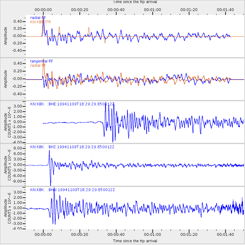
Signal To Noise
| Channel | StoN | STA | LTA |
| KN:KBK: :BHZ:19941109T18:29:29.850012Z | 56.40249 | 3.5307899E-6 | 6.2599895E-8 |
| KN:KBK: :BHN:19941109T18:29:29.850012Z | 9.007789 | 7.1187424E-7 | 7.902875E-8 |
| KN:KBK: :BHE:19941109T18:29:29.850012Z | 18.788486 | 1.2206563E-6 | 6.496832E-8 |
| Arrivals |
| Ps | 1.8 SECOND |
| PpPs | 6.0 SECOND |
| PsPs/PpSs | 7.8 SECOND |


