You are here: Home > Network List > AV - Alaska Volcano Observatory Stations List
> Station AUL Lava Flow, Augustine Volcano, Alaska > Earthquake Result Viewer
AUL Lava Flow, Augustine Volcano, Alaska - Earthquake Result Viewer
| Earthquake location: |
Santa Cruz Islands |
| Earthquake latitude/longitude: |
-12.1/166.6 |
| Earthquake time(UTC): |
2020/05/12 (133) 22:41:12 GMT |
| Earthquake Depth: |
107 km |
| Earthquake Magnitude: |
6.6 mww |
| Earthquake Catalog/Contributor: |
NEIC PDE/us |
|
| Network: |
AV Alaska Volcano Observatory |
| Station: |
AUL Lava Flow, Augustine Volcano, Alaska |
| Lat/Lon: |
59.38 N/153.44 W |
| Elevation: |
360 m |
|
| Distance: |
78.1 deg |
| Az: |
19.609 deg |
| Baz: |
219.892 deg |
| Ray Param: |
0.04960362 |
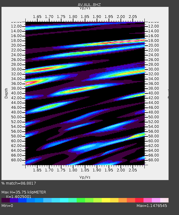
| Estimated Moho Depth: |
35.75 km |
| Estimated Crust Vp/Vs: |
1.60 |
| Assumed Crust Vp: |
5.989 km/s |
| Estimated Crust Vs: |
3.737 km/s |
| Estimated Crust Poisson's Ratio: |
0.18 |
|
| Radial Match: |
86.8817 % |
| Radial Bump: |
400 |
| Transverse Match: |
82.2811 % |
| Transverse Bump: |
400 |
| SOD ConfigId: |
21166931 |
| Insert Time: |
2020-05-26 22:46:00.594 +0000 |
| GWidth: |
2.5 |
| Max Bumps: |
400 |
| Tol: |
0.001 |
|

Signal To Noise
| Channel | StoN | STA | LTA |
| AV:AUL: :BHZ:20200512T22:52:28.559019Z | 10.108831 | 1.8043224E-6 | 1.7848971E-7 |
| AV:AUL: :BHN:20200512T22:52:28.559019Z | 4.287991 | 5.120436E-7 | 1.1941339E-7 |
| AV:AUL: :BHE:20200512T22:52:28.559019Z | 2.5366077 | 3.6286147E-7 | 1.4304989E-7 |
| Arrivals |
| Ps | 3.7 SECOND |
| PpPs | 15 SECOND |
| PsPs/PpSs | 19 SECOND |


