You are here: Home > Network List > AV - Alaska Volcano Observatory Stations List
> Station DT1 Dutton Round Hill, Mount Dutton, Alaska > Earthquake Result Viewer
DT1 Dutton Round Hill, Mount Dutton, Alaska - Earthquake Result Viewer
| Earthquake location: |
Santa Cruz Islands |
| Earthquake latitude/longitude: |
-12.1/166.6 |
| Earthquake time(UTC): |
2020/05/12 (133) 22:41:12 GMT |
| Earthquake Depth: |
107 km |
| Earthquake Magnitude: |
6.6 mww |
| Earthquake Catalog/Contributor: |
NEIC PDE/us |
|
| Network: |
AV Alaska Volcano Observatory |
| Station: |
DT1 Dutton Round Hill, Mount Dutton, Alaska |
| Lat/Lon: |
55.11 N/162.28 W |
| Elevation: |
198 m |
|
| Distance: |
71.9 deg |
| Az: |
18.186 deg |
| Baz: |
212.092 deg |
| Ray Param: |
0.053789545 |
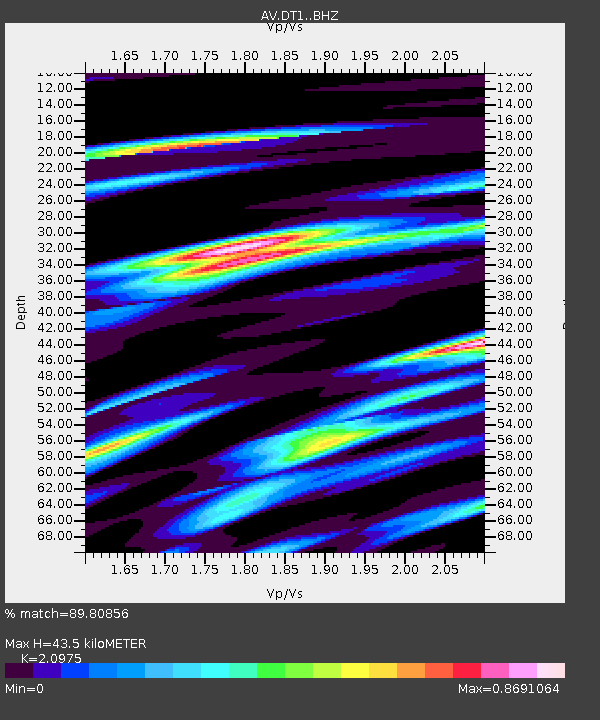
| Estimated Moho Depth: |
43.5 km |
| Estimated Crust Vp/Vs: |
2.10 |
| Assumed Crust Vp: |
5.989 km/s |
| Estimated Crust Vs: |
2.855 km/s |
| Estimated Crust Poisson's Ratio: |
0.35 |
|
| Radial Match: |
89.80856 % |
| Radial Bump: |
351 |
| Transverse Match: |
74.31543 % |
| Transverse Bump: |
400 |
| SOD ConfigId: |
21166931 |
| Insert Time: |
2020-05-26 22:46:11.546 +0000 |
| GWidth: |
2.5 |
| Max Bumps: |
400 |
| Tol: |
0.001 |
|

Signal To Noise
| Channel | StoN | STA | LTA |
| AV:DT1: :BHZ:20200512T22:51:52.559996Z | 15.301901 | 1.3170247E-6 | 8.6069356E-8 |
| AV:DT1: :BHN:20200512T22:51:52.559996Z | 7.1992755 | 6.6030725E-7 | 9.171857E-8 |
| AV:DT1: :BHE:20200512T22:51:52.559996Z | 3.6398077 | 3.8917506E-7 | 1.0692187E-7 |
| Arrivals |
| Ps | 8.2 SECOND |
| PpPs | 22 SECOND |
| PsPs/PpSs | 30 SECOND |


