You are here: Home > Network List > AV - Alaska Volcano Observatory Stations List
> Station PLK5 Mt. Peulik Volcano 5, Alaska > Earthquake Result Viewer
PLK5 Mt. Peulik Volcano 5, Alaska - Earthquake Result Viewer
| Earthquake location: |
Santa Cruz Islands |
| Earthquake latitude/longitude: |
-12.1/166.6 |
| Earthquake time(UTC): |
2020/05/12 (133) 22:41:12 GMT |
| Earthquake Depth: |
107 km |
| Earthquake Magnitude: |
6.6 mww |
| Earthquake Catalog/Contributor: |
NEIC PDE/us |
|
| Network: |
AV Alaska Volcano Observatory |
| Station: |
PLK5 Mt. Peulik Volcano 5, Alaska |
| Lat/Lon: |
58.00 N/156.88 W |
| Elevation: |
49 m |
|
| Distance: |
75.9 deg |
| Az: |
19.047 deg |
| Baz: |
216.83 deg |
| Ray Param: |
0.05109003 |
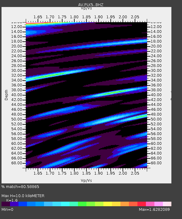
| Estimated Moho Depth: |
10.0 km |
| Estimated Crust Vp/Vs: |
1.60 |
| Assumed Crust Vp: |
6.1 km/s |
| Estimated Crust Vs: |
3.812 km/s |
| Estimated Crust Poisson's Ratio: |
0.18 |
|
| Radial Match: |
80.58865 % |
| Radial Bump: |
400 |
| Transverse Match: |
63.561977 % |
| Transverse Bump: |
400 |
| SOD ConfigId: |
21166931 |
| Insert Time: |
2020-05-26 22:47:10.465 +0000 |
| GWidth: |
2.5 |
| Max Bumps: |
400 |
| Tol: |
0.001 |
|
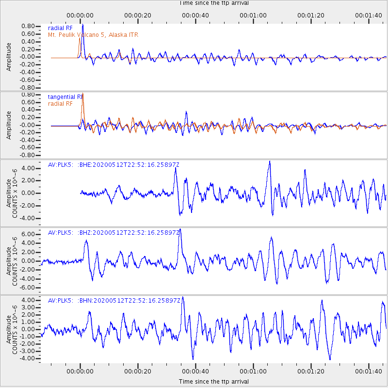
Signal To Noise
| Channel | StoN | STA | LTA |
| AV:PLK5: :BHZ:20200512T22:52:16.25897Z | 8.385644 | 2.5791833E-6 | 3.0757127E-7 |
| AV:PLK5: :BHN:20200512T22:52:16.25897Z | 3.111414 | 1.1518667E-6 | 3.7020683E-7 |
| AV:PLK5: :BHE:20200512T22:52:16.25897Z | 3.6038585 | 1.7920626E-6 | 4.972622E-7 |
| Arrivals |
| Ps | 1.0 SECOND |
| PpPs | 4.1 SECOND |
| PsPs/PpSs | 5.1 SECOND |


