You are here: Home > Network List > AV - Alaska Volcano Observatory Stations List
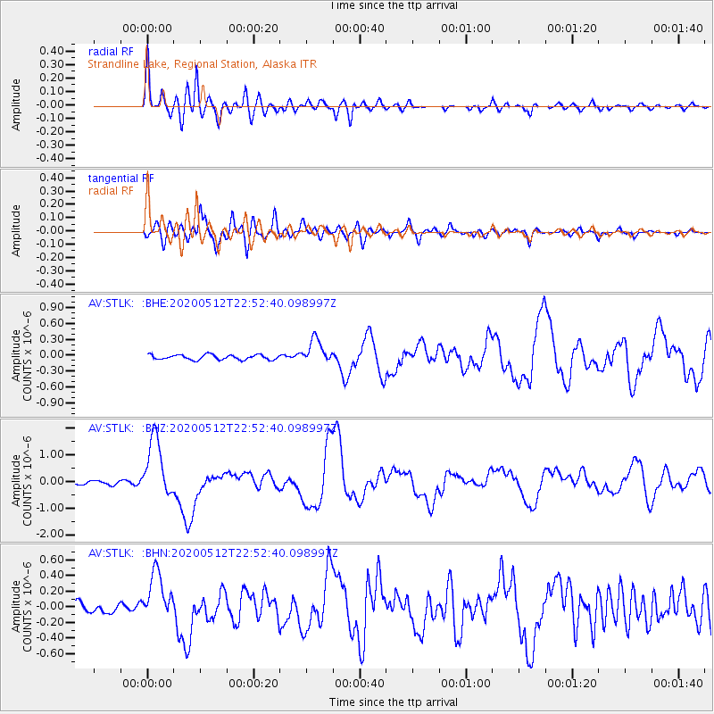
> Station STLK Strandline Lake, Regional Station, Alaska > Earthquake Result Viewer
STLK Strandline Lake, Regional Station, Alaska - Earthquake Result Viewer
| Earthquake location: |
Santa Cruz Islands |
| Earthquake latitude/longitude: |
-12.1/166.6 |
| Earthquake time(UTC): |
2020/05/12 (133) 22:41:12 GMT |
| Earthquake Depth: |
107 km |
| Earthquake Magnitude: |
6.6 mww |
| Earthquake Catalog/Contributor: |
NEIC PDE/us |
|
| Network: |
AV Alaska Volcano Observatory |
| Station: |
STLK Strandline Lake, Regional Station, Alaska |
| Lat/Lon: |
61.50 N/151.83 W |
| Elevation: |
945 m |
|
| Distance: |
80.3 deg |
| Az: |
18.819 deg |
| Baz: |
221.137 deg |
| Ray Param: |
0.048157543 |
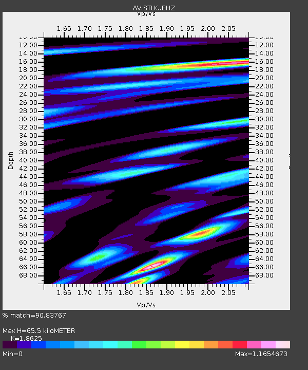
| Estimated Moho Depth: |
65.5 km |
| Estimated Crust Vp/Vs: |
1.86 |
| Assumed Crust Vp: |
6.302 km/s |
| Estimated Crust Vs: |
3.383 km/s |
| Estimated Crust Poisson's Ratio: |
0.30 |
|
| Radial Match: |
90.83767 % |
| Radial Bump: |
400 |
| Transverse Match: |
87.175835 % |
| Transverse Bump: |
400 |
| SOD ConfigId: |
21166931 |
| Insert Time: |
2020-05-26 22:47:33.197 +0000 |
| GWidth: |
2.5 |
| Max Bumps: |
400 |
| Tol: |
0.001 |
|
Signal To Noise
| Channel | StoN | STA | LTA |
| AV:STLK: :BHZ:20200512T22:52:40.098997Z | 19.858833 | 1.1263166E-6 | 5.6716154E-8 |
| AV:STLK: :BHN:20200512T22:52:40.098997Z | 5.9641137 | 3.139758E-7 | 5.2644168E-8 |
| AV:STLK: :BHE:20200512T22:52:40.098997Z | 4.9627414 | 2.3190005E-7 | 4.672821E-8 |
| Arrivals |
| Ps | 9.2 SECOND |
| PpPs | 29 SECOND |
| PsPs/PpSs | 38 SECOND |


