KBK KN.KBK - Earthquake Result Viewer
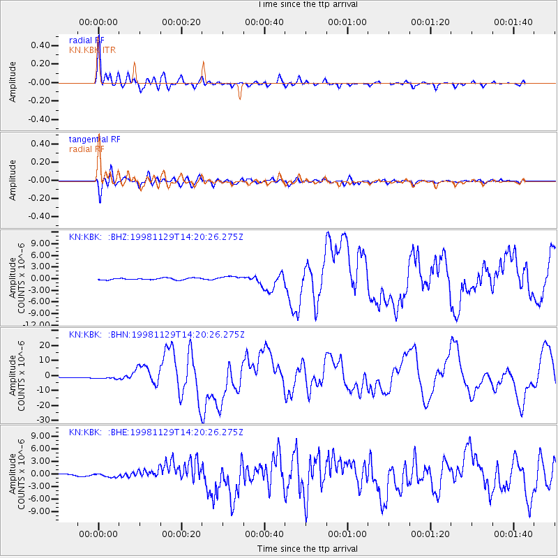
Earthquake location: Ceram Sea
Earthquake latitude/longitude: -2.1/124.9
Earthquake time(UTC): 1998/11/29 (333) 14:10:31 GMT
Earthquake Depth: 33 km
Earthquake Magnitude: 6.5 MB, 7.7 MS, 8.1 UNKNOWN, 7.8 MW
Earthquake Catalog/Contributor: WHDF/NEIC
Network: KN Kyrgyz Seismic Telemetry Network
Station: KBK KN.KBK
Lat/Lon: 42.66 N/74.95 E
Elevation: 1760 m
Distance: 63.2 deg
Az: 320.777 deg
Baz: 121.059 deg
Ray Param: 0.059649225
Estimated Moho Depth: 15.75 km
Estimated Crust Vp/Vs: 2.10
Assumed Crust Vp: 6.306 km/s
Estimated Crust Vs: 3.006 km/s
Estimated Crust Poisson's Ratio: 0.35
Radial Match: 94.44433 %
Radial Bump: 400
Transverse Match: 91.558716 %
Transverse Bump: 400
SOD ConfigId: 4480
Insert Time: 2010-03-08 20:00:36.414 +0000
GWidth: 2.5
Max Bumps: 400
Tol: 0.001

Signal To Noise

ChannelStoNSTALTA
KN:KBK: :BHN:19981129T14:20:26.275Z2.97225861.0868534E-63.6566584E-7
KN:KBK: :BHE:19981129T14:20:26.275Z1.70990993.638913E-72.1281315E-7
KN:KBK: :BHZ:19981129T14:20:26.275Z2.4013265.3893467E-72.2443211E-7
Arrivals
Ps2.8 SECOND
PpPs7.5 SECOND
PsPs/PpSs10 SECOND