You are here: Home > Network List > CC - Cascade Chain Volcano Monitoring Stations List
> Station SHRK Shell Rock, OR, USA > Earthquake Result Viewer
SHRK Shell Rock, OR, USA - Earthquake Result Viewer
| Earthquake location: |
Santa Cruz Islands |
| Earthquake latitude/longitude: |
-12.1/166.6 |
| Earthquake time(UTC): |
2020/05/12 (133) 22:41:12 GMT |
| Earthquake Depth: |
107 km |
| Earthquake Magnitude: |
6.6 mww |
| Earthquake Catalog/Contributor: |
NEIC PDE/us |
|
| Network: |
CC Cascade Chain Volcano Monitoring |
| Station: |
SHRK Shell Rock, OR, USA |
| Lat/Lon: |
45.46 N/121.53 W |
| Elevation: |
1319 m |
|
| Distance: |
86.1 deg |
| Az: |
42.078 deg |
| Baz: |
248.667 deg |
| Ray Param: |
0.0440344 |
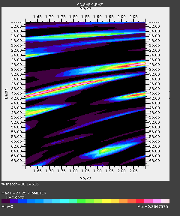
| Estimated Moho Depth: |
27.25 km |
| Estimated Crust Vp/Vs: |
2.10 |
| Assumed Crust Vp: |
6.597 km/s |
| Estimated Crust Vs: |
3.145 km/s |
| Estimated Crust Poisson's Ratio: |
0.35 |
|
| Radial Match: |
80.14516 % |
| Radial Bump: |
400 |
| Transverse Match: |
68.79489 % |
| Transverse Bump: |
400 |
| SOD ConfigId: |
21166931 |
| Insert Time: |
2020-05-26 22:49:24.769 +0000 |
| GWidth: |
2.5 |
| Max Bumps: |
400 |
| Tol: |
0.001 |
|

Signal To Noise
| Channel | StoN | STA | LTA |
| CC:SHRK: :BHZ:20200512T22:53:10.190Z | 11.772224 | 2.3149823E-6 | 1.9664782E-7 |
| CC:SHRK: :BHN:20200512T22:53:10.190Z | 2.0967045 | 5.556123E-7 | 2.6499313E-7 |
| CC:SHRK: :BHE:20200512T22:53:10.190Z | 1.8701534 | 5.330851E-7 | 2.8504886E-7 |
| Arrivals |
| Ps | 4.6 SECOND |
| PpPs | 13 SECOND |
| PsPs/PpSs | 17 SECOND |


