You are here: Home > Network List > KN - Kyrgyz Seismic Telemetry Network Stations List
> Station KBK KN.KBK > Earthquake Result Viewer
KBK KN.KBK - Earthquake Result Viewer
| Earthquake location: |
Northern Sumatra, Indonesia |
| Earthquake latitude/longitude: |
3.4/99.1 |
| Earthquake time(UTC): |
2006/12/01 (335) 03:58:21 GMT |
| Earthquake Depth: |
206 km |
| Earthquake Magnitude: |
6.0 MB, 6.3 MW, 6.3 MW |
| Earthquake Catalog/Contributor: |
WHDF/NEIC |
|
| Network: |
KN Kyrgyz Seismic Telemetry Network |
| Station: |
KBK KN.KBK |
| Lat/Lon: |
42.66 N/74.95 E |
| Elevation: |
1760 m |
|
| Distance: |
44.6 deg |
| Az: |
334.566 deg |
| Baz: |
144.467 deg |
| Ray Param: |
0.07099846 |
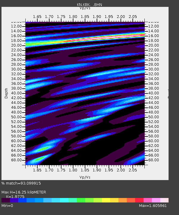
| Estimated Moho Depth: |
16.25 km |
| Estimated Crust Vp/Vs: |
1.98 |
| Assumed Crust Vp: |
6.306 km/s |
| Estimated Crust Vs: |
3.189 km/s |
| Estimated Crust Poisson's Ratio: |
0.33 |
|
| Radial Match: |
93.099915 % |
| Radial Bump: |
400 |
| Transverse Match: |
90.73405 % |
| Transverse Bump: |
400 |
| SOD ConfigId: |
2564 |
| Insert Time: |
2010-03-08 20:01:08.063 +0000 |
| GWidth: |
2.5 |
| Max Bumps: |
400 |
| Tol: |
0.001 |
|
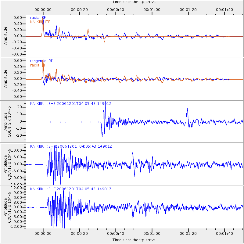
Signal To Noise
| Channel | StoN | STA | LTA |
| KN:KBK: :BHN:20061201T04:05:43.14901Z | 33.934296 | 4.519991E-6 | 1.3319831E-7 |
| KN:KBK: :BHE:20061201T04:05:43.14901Z | 23.473278 | 3.184176E-6 | 1.3565109E-7 |
| KN:KBK: :BHZ:20061201T04:05:43.14901Z | 92.36082 | 1.0132733E-5 | 1.0970815E-7 |
| Arrivals |
| Ps | 2.7 SECOND |
| PpPs | 7.3 SECOND |
| PsPs/PpSs | 9.9 SECOND |


