You are here: Home > Network List > CN - Canadian National Seismograph Network Stations List
> Station BAIB Barry Inlet, BC, CA > Earthquake Result Viewer
BAIB Barry Inlet, BC, CA - Earthquake Result Viewer
| Earthquake location: |
Santa Cruz Islands |
| Earthquake latitude/longitude: |
-12.1/166.6 |
| Earthquake time(UTC): |
2020/05/12 (133) 22:41:12 GMT |
| Earthquake Depth: |
107 km |
| Earthquake Magnitude: |
6.6 mww |
| Earthquake Catalog/Contributor: |
NEIC PDE/us |
|
| Network: |
CN Canadian National Seismograph Network |
| Station: |
BAIB Barry Inlet, BC, CA |
| Lat/Lon: |
52.58 N/131.75 W |
| Elevation: |
804 m |
|
| Distance: |
83.1 deg |
| Az: |
32.731 deg |
| Baz: |
240.072 deg |
| Ray Param: |
0.046165965 |
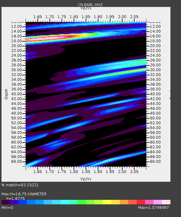
| Estimated Moho Depth: |
16.75 km |
| Estimated Crust Vp/Vs: |
1.68 |
| Assumed Crust Vp: |
6.134 km/s |
| Estimated Crust Vs: |
3.657 km/s |
| Estimated Crust Poisson's Ratio: |
0.22 |
|
| Radial Match: |
83.15221 % |
| Radial Bump: |
277 |
| Transverse Match: |
45.960903 % |
| Transverse Bump: |
400 |
| SOD ConfigId: |
21166931 |
| Insert Time: |
2020-05-26 22:51:30.807 +0000 |
| GWidth: |
2.5 |
| Max Bumps: |
400 |
| Tol: |
0.001 |
|

Signal To Noise
| Channel | StoN | STA | LTA |
| CN:BAIB: :HHZ:20200512T22:52:55.140013Z | 7.886141 | 2.2042304E-6 | 2.7950685E-7 |
| CN:BAIB: :HHN:20200512T22:52:55.140013Z | 1.6572945 | 9.682298E-7 | 5.842231E-7 |
| CN:BAIB: :HHE:20200512T22:52:55.140013Z | 1.7244959 | 7.231061E-7 | 4.1931446E-7 |
| Arrivals |
| Ps | 1.9 SECOND |
| PpPs | 7.1 SECOND |
| PsPs/PpSs | 9.0 SECOND |


