You are here: Home > Network List > IE - INL Seismic Monitoring Program Stations List
> Station LLRI Little Lost River, Idaho, USA > Earthquake Result Viewer
LLRI Little Lost River, Idaho, USA - Earthquake Result Viewer
| Earthquake location: |
Santa Cruz Islands |
| Earthquake latitude/longitude: |
-12.1/166.6 |
| Earthquake time(UTC): |
2020/05/12 (133) 22:41:12 GMT |
| Earthquake Depth: |
107 km |
| Earthquake Magnitude: |
6.6 mww |
| Earthquake Catalog/Contributor: |
NEIC PDE/us |
|
| Network: |
IE INL Seismic Monitoring Program |
| Station: |
LLRI Little Lost River, Idaho, USA |
| Lat/Lon: |
43.72 N/112.93 W |
| Elevation: |
1471 m |
|
| Distance: |
91.4 deg |
| Az: |
45.653 deg |
| Baz: |
254.763 deg |
| Ray Param: |
0.041568913 |
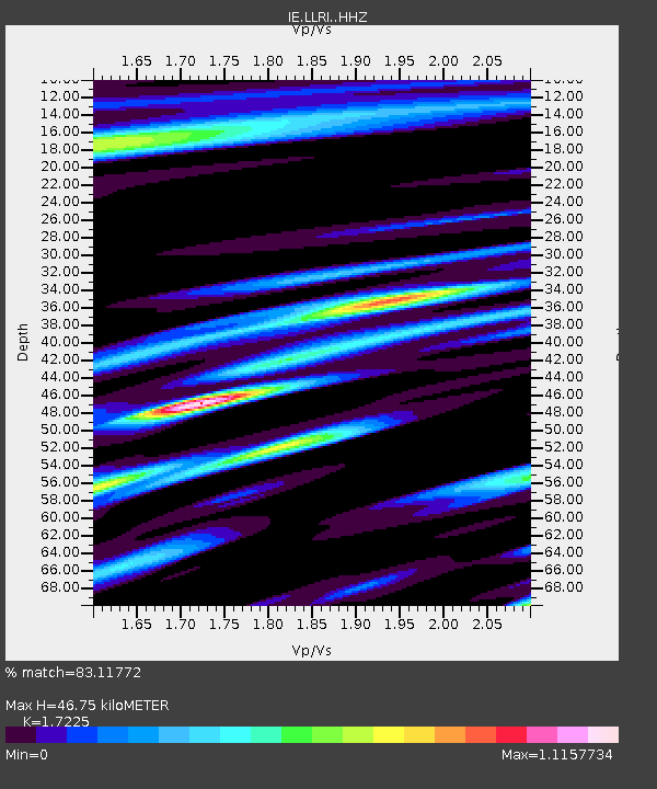
| Estimated Moho Depth: |
46.75 km |
| Estimated Crust Vp/Vs: |
1.72 |
| Assumed Crust Vp: |
6.279 km/s |
| Estimated Crust Vs: |
3.645 km/s |
| Estimated Crust Poisson's Ratio: |
0.25 |
|
| Radial Match: |
83.11772 % |
| Radial Bump: |
391 |
| Transverse Match: |
75.72755 % |
| Transverse Bump: |
400 |
| SOD ConfigId: |
21166931 |
| Insert Time: |
2020-05-26 22:54:13.167 +0000 |
| GWidth: |
2.5 |
| Max Bumps: |
400 |
| Tol: |
0.001 |
|

Signal To Noise
| Channel | StoN | STA | LTA |
| IE:LLRI: :HHZ:20200512T22:53:35.049986Z | 15.076374 | 1.5994724E-6 | 1.0609132E-7 |
| IE:LLRI: :HHN:20200512T22:53:35.049986Z | 2.063745 | 4.0454407E-7 | 1.9602423E-7 |
| IE:LLRI: :HHE:20200512T22:53:35.049986Z | 4.396939 | 5.9388236E-7 | 1.3506724E-7 |
| Arrivals |
| Ps | 5.5 SECOND |
| PpPs | 20 SECOND |
| PsPs/PpSs | 25 SECOND |


