You are here: Home > Network List > KN - Kyrgyz Seismic Telemetry Network Stations List
> Station KBK KN.KBK > Earthquake Result Viewer
KBK KN.KBK - Earthquake Result Viewer
| Earthquake location: |
South Of Java, Indonesia |
| Earthquake latitude/longitude: |
-9.4/108.3 |
| Earthquake time(UTC): |
2006/07/17 (198) 15:45:59 GMT |
| Earthquake Depth: |
21 km |
| Earthquake Magnitude: |
5.9 MB, 5.9 MS, 6.1 MW, 6.1 MW |
| Earthquake Catalog/Contributor: |
WHDF/NEIC |
|
| Network: |
KN Kyrgyz Seismic Telemetry Network |
| Station: |
KBK KN.KBK |
| Lat/Lon: |
42.66 N/74.95 E |
| Elevation: |
1760 m |
|
| Distance: |
60.1 deg |
| Az: |
332.098 deg |
| Baz: |
141.251 deg |
| Ray Param: |
0.0617125 |
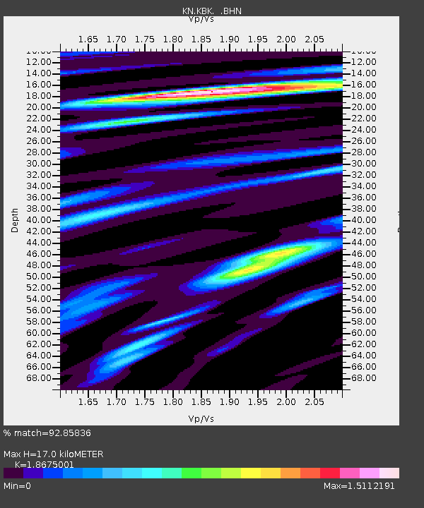
| Estimated Moho Depth: |
17.0 km |
| Estimated Crust Vp/Vs: |
1.87 |
| Assumed Crust Vp: |
6.306 km/s |
| Estimated Crust Vs: |
3.377 km/s |
| Estimated Crust Poisson's Ratio: |
0.30 |
|
| Radial Match: |
92.85836 % |
| Radial Bump: |
400 |
| Transverse Match: |
87.81473 % |
| Transverse Bump: |
400 |
| SOD ConfigId: |
2665 |
| Insert Time: |
2010-03-08 20:01:49.895 +0000 |
| GWidth: |
2.5 |
| Max Bumps: |
400 |
| Tol: |
0.001 |
|
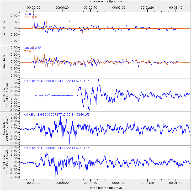
Signal To Noise
| Channel | StoN | STA | LTA |
| KN:KBK: :BHN:20060717T15:55:34.624016Z | 4.5627418 | 3.8015392E-7 | 8.3317E-8 |
| KN:KBK: :BHE:20060717T15:55:34.624016Z | 4.8852315 | 3.3462678E-7 | 6.849763E-8 |
| KN:KBK: :BHZ:20060717T15:55:34.624016Z | 16.293428 | 1.2979048E-6 | 7.965818E-8 |
| Arrivals |
| Ps | 2.4 SECOND |
| PpPs | 7.4 SECOND |
| PsPs/PpSs | 9.8 SECOND |


