You are here: Home > Network List > KN - Kyrgyz Seismic Telemetry Network Stations List
> Station KBK KN.KBK > Earthquake Result Viewer
KBK KN.KBK - Earthquake Result Viewer
| Earthquake location: |
South Of Java, Indonesia |
| Earthquake latitude/longitude: |
-9.3/107.4 |
| Earthquake time(UTC): |
2006/07/17 (198) 08:19:28 GMT |
| Earthquake Depth: |
34 km |
| Earthquake Magnitude: |
6.1 MB, 7.2 MS, 7.7 MW, 7.2 MW |
| Earthquake Catalog/Contributor: |
WHDF/NEIC |
|
| Network: |
KN Kyrgyz Seismic Telemetry Network |
| Station: |
KBK KN.KBK |
| Lat/Lon: |
42.66 N/74.95 E |
| Elevation: |
1760 m |
|
| Distance: |
59.6 deg |
| Az: |
332.662 deg |
| Baz: |
142.081 deg |
| Ray Param: |
0.062044762 |
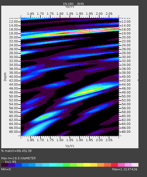
| Estimated Moho Depth: |
16.5 km |
| Estimated Crust Vp/Vs: |
1.95 |
| Assumed Crust Vp: |
6.306 km/s |
| Estimated Crust Vs: |
3.234 km/s |
| Estimated Crust Poisson's Ratio: |
0.32 |
|
| Radial Match: |
96.45139 % |
| Radial Bump: |
400 |
| Transverse Match: |
87.67445 % |
| Transverse Bump: |
400 |
| SOD ConfigId: |
2665 |
| Insert Time: |
2010-03-08 20:01:51.537 +0000 |
| GWidth: |
2.5 |
| Max Bumps: |
400 |
| Tol: |
0.001 |
|
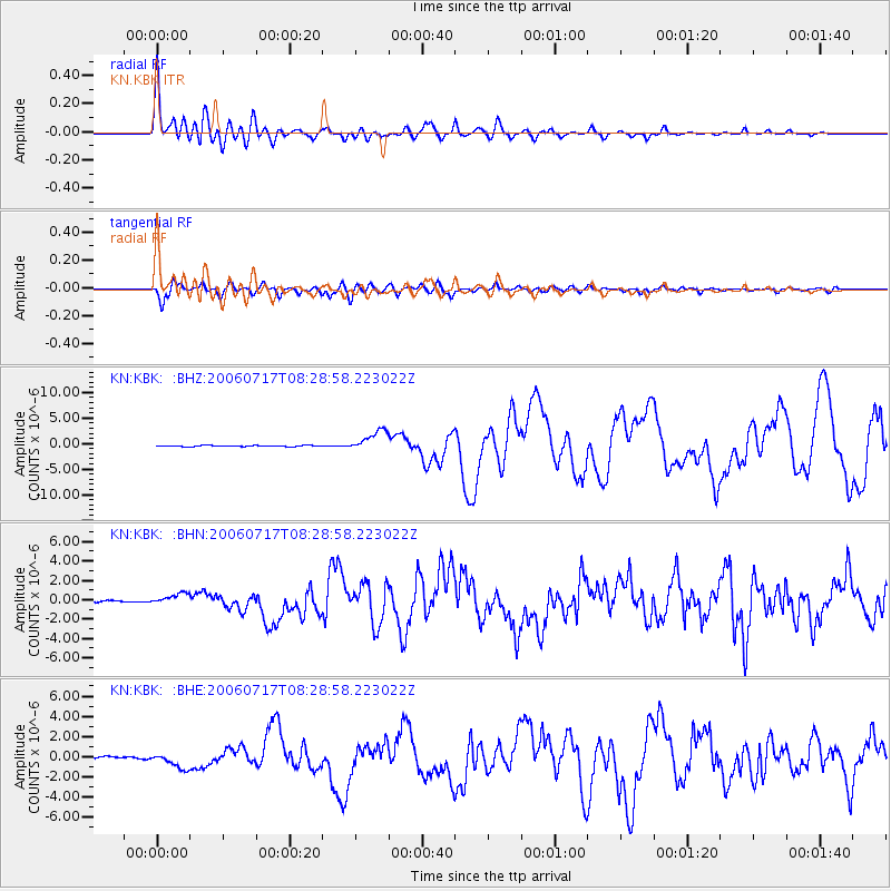
Signal To Noise
| Channel | StoN | STA | LTA |
| KN:KBK: :BHN:20060717T08:28:58.223022Z | 6.623682 | 6.4644144E-7 | 9.759548E-8 |
| KN:KBK: :BHE:20060717T08:28:58.223022Z | 5.4396787 | 7.3413713E-7 | 1.3495965E-7 |
| KN:KBK: :BHZ:20060717T08:28:58.223022Z | 20.647276 | 2.0793034E-6 | 1.0070594E-7 |
| Arrivals |
| Ps | 2.6 SECOND |
| PpPs | 7.4 SECOND |
| PsPs/PpSs | 10.0 SECOND |


