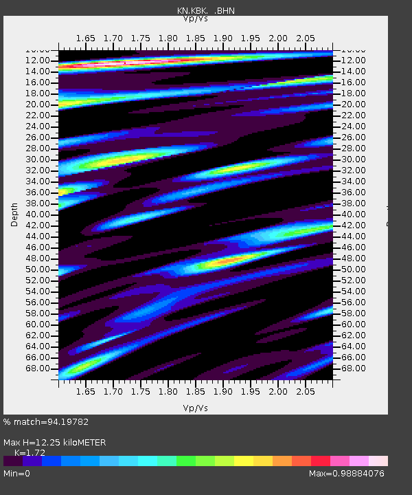
KBK KN.KBK - Earthquake Result Viewer
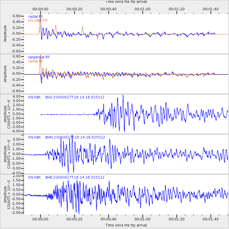
Earthquake location: Nicobar Islands, India Region
Earthquake latitude/longitude: 6.5/92.8
Earthquake time(UTC): 2006/06/27 (178) 18:07:22 GMT
Earthquake Depth: 29 km
Earthquake Magnitude: 5.8 MB, 6.1 MS, 6.2 MW, 5.9 MW
Earthquake Catalog/Contributor: WHDF/NEIC
Network: KN Kyrgyz Seismic Telemetry Network
Station: KBK KN.KBK
Lat/Lon: 42.66 N/74.95 E
Elevation: 1760 m
Distance: 39.3 deg
Az: 339.096 deg
Baz: 151.275 deg
Ray Param: 0.07500463
Estimated Moho Depth: 12.25 km
Estimated Crust Vp/Vs: 1.72
Assumed Crust Vp: 6.306 km/s
Estimated Crust Vs: 3.666 km/s
Estimated Crust Poisson's Ratio: 0.24
Radial Match: 94.19782 %
Radial Bump: 351
Transverse Match: 86.886955 %
Transverse Bump: 400
SOD ConfigId: 2665
Insert Time: 2010-03-08 20:01:55.555 +0000
GWidth: 2.5
Max Bumps: 400
Tol: 0.001

Signal To Noise

ChannelStoNSTALTA
KN:KBK: :BHN:20060627T18:14:18.62501Z2.8956642.1230271E-77.331745E-8
KN:KBK: :BHE:20060627T18:14:18.62501Z3.21078091.959643E-76.103322E-8
KN:KBK: :BHZ:20060627T18:14:18.62501Z12.24432854.0552334E-73.311928E-8
Arrivals
Ps1.5 SECOND
PpPs4.9 SECOND
PsPs/PpSs6.4 SECOND