You are here: Home > Network List > TA - USArray Transportable Network (new EarthScope stations) Stations List
> Station C18K Utukok River, AK, USA > Earthquake Result Viewer
C18K Utukok River, AK, USA - Earthquake Result Viewer
| Earthquake location: |
Santa Cruz Islands |
| Earthquake latitude/longitude: |
-12.1/166.6 |
| Earthquake time(UTC): |
2020/05/12 (133) 22:41:12 GMT |
| Earthquake Depth: |
107 km |
| Earthquake Magnitude: |
6.6 mww |
| Earthquake Catalog/Contributor: |
NEIC PDE/us |
|
| Network: |
TA USArray Transportable Network (new EarthScope stations) |
| Station: |
C18K Utukok River, AK, USA |
| Lat/Lon: |
68.65 N/161.19 W |
| Elevation: |
845 m |
|
| Distance: |
83.7 deg |
| Az: |
11.31 deg |
| Baz: |
211.589 deg |
| Ray Param: |
0.04577898 |
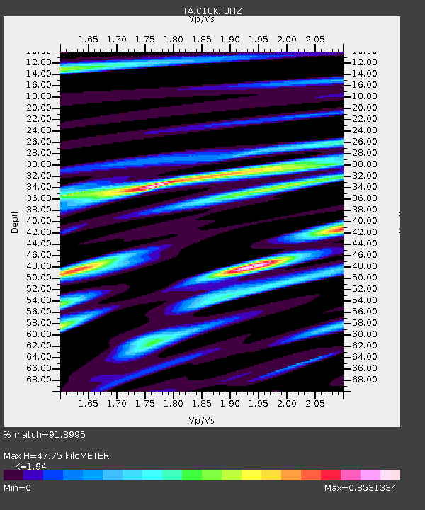
| Estimated Moho Depth: |
47.75 km |
| Estimated Crust Vp/Vs: |
1.94 |
| Assumed Crust Vp: |
5.906 km/s |
| Estimated Crust Vs: |
3.045 km/s |
| Estimated Crust Poisson's Ratio: |
0.32 |
|
| Radial Match: |
91.8995 % |
| Radial Bump: |
400 |
| Transverse Match: |
86.289024 % |
| Transverse Bump: |
400 |
| SOD ConfigId: |
21166931 |
| Insert Time: |
2020-05-26 22:58:51.365 +0000 |
| GWidth: |
2.5 |
| Max Bumps: |
400 |
| Tol: |
0.001 |
|

Signal To Noise
| Channel | StoN | STA | LTA |
| TA:C18K: :BHZ:20200512T22:52:57.900022Z | 23.179209 | 2.4622664E-6 | 1.0622737E-7 |
| TA:C18K: :BHN:20200512T22:52:57.900022Z | 6.3371973 | 6.7704946E-7 | 1.0683736E-7 |
| TA:C18K: :BHE:20200512T22:52:57.900022Z | 3.1840425 | 5.087073E-7 | 1.5976774E-7 |
| Arrivals |
| Ps | 7.7 SECOND |
| PpPs | 23 SECOND |
| PsPs/PpSs | 31 SECOND |


