You are here: Home > Network List > TA - USArray Transportable Network (new EarthScope stations) Stations List
> Station C36M Paulatuk, NT, CAN > Earthquake Result Viewer
C36M Paulatuk, NT, CAN - Earthquake Result Viewer
| Earthquake location: |
Santa Cruz Islands |
| Earthquake latitude/longitude: |
-12.1/166.6 |
| Earthquake time(UTC): |
2020/05/12 (133) 22:41:12 GMT |
| Earthquake Depth: |
107 km |
| Earthquake Magnitude: |
6.6 mww |
| Earthquake Catalog/Contributor: |
NEIC PDE/us |
|
| Network: |
TA USArray Transportable Network (new EarthScope stations) |
| Station: |
C36M Paulatuk, NT, CAN |
| Lat/Lon: |
69.35 N/124.07 W |
| Elevation: |
10 m |
|
| Distance: |
94.1 deg |
| Az: |
19.432 deg |
| Baz: |
246.531 deg |
| Ray Param: |
0.041056402 |
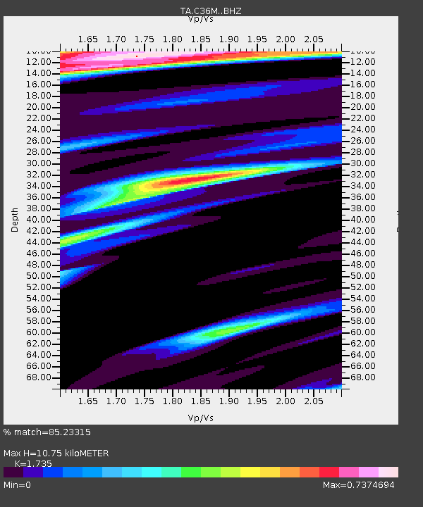
| Estimated Moho Depth: |
10.75 km |
| Estimated Crust Vp/Vs: |
1.74 |
| Assumed Crust Vp: |
6.459 km/s |
| Estimated Crust Vs: |
3.723 km/s |
| Estimated Crust Poisson's Ratio: |
0.25 |
|
| Radial Match: |
85.23315 % |
| Radial Bump: |
264 |
| Transverse Match: |
79.39447 % |
| Transverse Bump: |
364 |
| SOD ConfigId: |
21166931 |
| Insert Time: |
2020-05-26 22:58:59.278 +0000 |
| GWidth: |
2.5 |
| Max Bumps: |
400 |
| Tol: |
0.001 |
|

Signal To Noise
| Channel | StoN | STA | LTA |
| TA:C36M: :BHZ:20200512T22:53:47.275022Z | 8.862778 | 8.2283674E-7 | 9.284186E-8 |
| TA:C36M: :BHN:20200512T22:53:47.275022Z | 2.4811292 | 1.9260399E-7 | 7.762755E-8 |
| TA:C36M: :BHE:20200512T22:53:47.275022Z | 3.2943082 | 2.6893937E-7 | 8.163759E-8 |
| Arrivals |
| Ps | 1.2 SECOND |
| PpPs | 4.5 SECOND |
| PsPs/PpSs | 5.7 SECOND |


