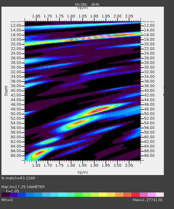
KBK KN.KBK - Earthquake Result Viewer
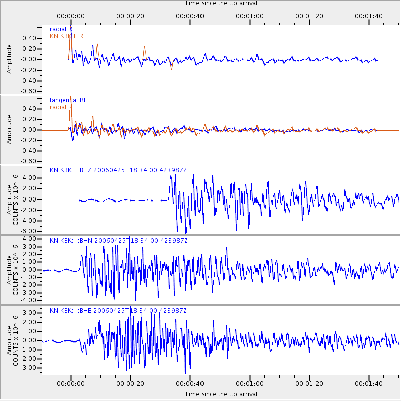
Earthquake location: Off W Coast Of Northern Sumatra
Earthquake latitude/longitude: 2.0/97.0
Earthquake time(UTC): 2006/04/25 (115) 18:26:17 GMT
Earthquake Depth: 21 km
Earthquake Magnitude: 5.8 MB, 6.1 MS, 6.3 MW, 6.1 MW
Earthquake Catalog/Contributor: WHDF/NEIC
Network: KN Kyrgyz Seismic Telemetry Network
Station: KBK KN.KBK
Lat/Lon: 42.66 N/74.95 E
Elevation: 1760 m
Distance: 45.0 deg
Az: 336.96 deg
Baz: 147.98 deg
Ray Param: 0.07151385
Estimated Moho Depth: 17.25 km
Estimated Crust Vp/Vs: 1.85
Assumed Crust Vp: 6.306 km/s
Estimated Crust Vs: 3.409 km/s
Estimated Crust Poisson's Ratio: 0.29
Radial Match: 93.2269 %
Radial Bump: 400
Transverse Match: 90.459 %
Transverse Bump: 400
SOD ConfigId: 2669
Insert Time: 2010-03-08 20:02:26.535 +0000
GWidth: 2.5
Max Bumps: 400
Tol: 0.001

Signal To Noise

ChannelStoNSTALTA
KN:KBK: :BHN:20060425T18:34:00.423987Z5.86027536.846833E-71.1683466E-7
KN:KBK: :BHE:20060425T18:34:00.423987Z2.97272133.787243E-71.2739987E-7
KN:KBK: :BHZ:20060425T18:34:00.423987Z12.9273611.5970256E-61.2353841E-7
Arrivals
Ps2.5 SECOND
PpPs7.3 SECOND
PsPs/PpSs9.8 SECOND