You are here: Home > Network List > TA - USArray Transportable Network (new EarthScope stations) Stations List
> Station G23K Bananza Creek, AK, USA > Earthquake Result Viewer
G23K Bananza Creek, AK, USA - Earthquake Result Viewer

| Earthquake location: |
Santa Cruz Islands |
| Earthquake latitude/longitude: |
-12.1/166.6 |
| Earthquake time(UTC): |
2020/05/12 (133) 22:41:12 GMT |
| Earthquake Depth: |
107 km |
| Earthquake Magnitude: |
6.6 mww |
| Earthquake Catalog/Contributor: |
NEIC PDE/us |
|
| Network: |
TA USArray Transportable Network (new EarthScope stations) |
| Station: |
G23K Bananza Creek, AK, USA |
| Lat/Lon: |
66.71 N/150.02 W |
| Elevation: |
746 m |
|
| Distance: |
84.7 deg |
| Az: |
15.903 deg |
| Baz: |
222.384 deg |
| Ray Param: |
0.045065776 |
| Estimated Moho Depth: |
66.5 km |
| Estimated Crust Vp/Vs: |
1.62 |
| Assumed Crust Vp: |
6.577 km/s |
| Estimated Crust Vs: |
4.053 km/s |
| Estimated Crust Poisson's Ratio: |
0.19 |
|
| Radial Match: |
97.68117 % |
| Radial Bump: |
286 |
| Transverse Match: |
86.78846 % |
| Transverse Bump: |
400 |
| SOD ConfigId: |
21166931 |
| Insert Time: |
2020-05-26 22:59:56.210 +0000 |
| GWidth: |
2.5 |
| Max Bumps: |
400 |
| Tol: |
0.001 |
|
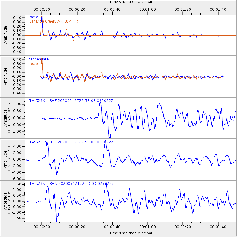
Signal To Noise
| Channel | StoN | STA | LTA |
| TA:G23K: :BHZ:20200512T22:53:03.025022Z | 40.184372 | 2.5299773E-6 | 6.295924E-8 |
| TA:G23K: :BHN:20200512T22:53:03.025022Z | 12.451379 | 6.347272E-7 | 5.0976457E-8 |
| TA:G23K: :BHE:20200512T22:53:03.025022Z | 11.901658 | 5.660249E-7 | 4.755849E-8 |
| Arrivals |
| Ps | 6.5 SECOND |
| PpPs | 26 SECOND |
| PsPs/PpSs | 32 SECOND |


