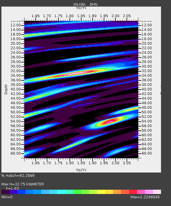
KBK KN.KBK - Earthquake Result Viewer
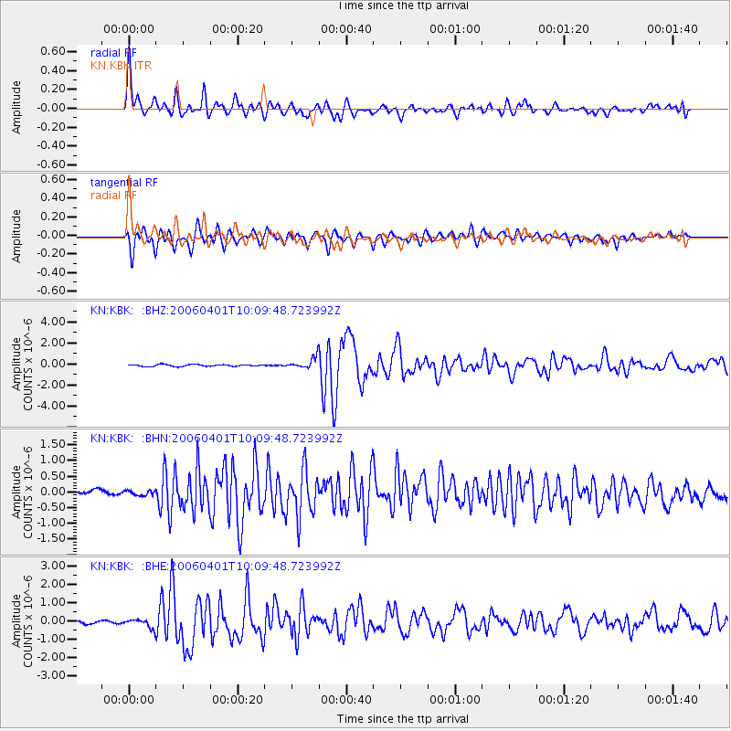
Earthquake location: Taiwan Region
Earthquake latitude/longitude: 22.9/121.3
Earthquake time(UTC): 2006/04/01 (091) 10:02:19 GMT
Earthquake Depth: 9.0 km
Earthquake Magnitude: 6.0 MB, 6.1 MS, 6.2 MW, 6.1 MW
Earthquake Catalog/Contributor: WHDF/NEIC
Network: KN Kyrgyz Seismic Telemetry Network
Station: KBK KN.KBK
Lat/Lon: 42.66 N/74.95 E
Elevation: 1760 m
Distance: 43.1 deg
Az: 308.594 deg
Baz: 102.256 deg
Ray Param: 0.07280001
Estimated Moho Depth: 32.75 km
Estimated Crust Vp/Vs: 1.83
Assumed Crust Vp: 6.306 km/s
Estimated Crust Vs: 3.446 km/s
Estimated Crust Poisson's Ratio: 0.29
Radial Match: 92.2569 %
Radial Bump: 400
Transverse Match: 86.3962 %
Transverse Bump: 400
SOD ConfigId: 2669
Insert Time: 2010-03-08 20:02:35.913 +0000
GWidth: 2.5
Max Bumps: 400
Tol: 0.001

Signal To Noise

ChannelStoNSTALTA
KN:KBK: :BHN:20060401T10:09:48.723992Z1.04877037.6595065E-87.3033206E-8
KN:KBK: :BHE:20060401T10:09:48.723992Z3.17598682.433282E-77.6614995E-8
KN:KBK: :BHZ:20060401T10:09:48.723992Z6.04248485.3607124E-78.8717016E-8
Arrivals
Ps4.6 SECOND
PpPs14 SECOND
PsPs/PpSs18 SECOND