You are here: Home > Network List > TA - USArray Transportable Network (new EarthScope stations) Stations List
> Station K17K Iditarod, AK, USA > Earthquake Result Viewer
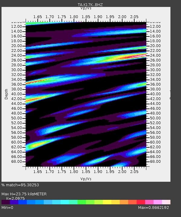
K17K Iditarod, AK, USA - Earthquake Result Viewer
| Earthquake location: |
Santa Cruz Islands |
| Earthquake latitude/longitude: |
-12.1/166.6 |
| Earthquake time(UTC): |
2020/05/12 (133) 22:41:12 GMT |
| Earthquake Depth: |
107 km |
| Earthquake Magnitude: |
6.6 mww |
| Earthquake Catalog/Contributor: |
NEIC PDE/us |
|
| Network: |
TA USArray Transportable Network (new EarthScope stations) |
| Station: |
K17K Iditarod, AK, USA |
| Lat/Lon: |
62.72 N/158.30 W |
| Elevation: |
339 m |
|
| Distance: |
79.4 deg |
| Az: |
15.622 deg |
| Baz: |
214.862 deg |
| Ray Param: |
0.048774756 |
| Estimated Moho Depth: |
23.75 km |
| Estimated Crust Vp/Vs: |
2.10 |
| Assumed Crust Vp: |
6.276 km/s |
| Estimated Crust Vs: |
2.992 km/s |
| Estimated Crust Poisson's Ratio: |
0.35 |
|
| Radial Match: |
95.38253 % |
| Radial Bump: |
400 |
| Transverse Match: |
81.65616 % |
| Transverse Bump: |
400 |
| SOD ConfigId: |
21166931 |
| Insert Time: |
2020-05-26 23:00:30.723 +0000 |
| GWidth: |
2.5 |
| Max Bumps: |
400 |
| Tol: |
0.001 |
|

Signal To Noise
| Channel | StoN | STA | LTA |
| TA:K17K: :BHZ:20200512T22:52:35.224974Z | 28.753504 | 2.4662156E-6 | 8.5770964E-8 |
| TA:K17K: :BHN:20200512T22:52:35.224974Z | 10.183031 | 6.9679913E-7 | 6.8427475E-8 |
| TA:K17K: :BHE:20200512T22:52:35.224974Z | 4.3946233 | 6.5107304E-7 | 1.4815218E-7 |
| Arrivals |
| Ps | 4.3 SECOND |
| PpPs | 11 SECOND |
| PsPs/PpSs | 16 SECOND |


