You are here: Home > Network List > TA - USArray Transportable Network (new EarthScope stations) Stations List
> Station L29M Grand Valley Creek, YT, CAN > Earthquake Result Viewer
L29M Grand Valley Creek, YT, CAN - Earthquake Result Viewer
| Earthquake location: |
Santa Cruz Islands |
| Earthquake latitude/longitude: |
-12.1/166.6 |
| Earthquake time(UTC): |
2020/05/12 (133) 22:41:12 GMT |
| Earthquake Depth: |
107 km |
| Earthquake Magnitude: |
6.6 mww |
| Earthquake Catalog/Contributor: |
NEIC PDE/us |
|
| Network: |
TA USArray Transportable Network (new EarthScope stations) |
| Station: |
L29M Grand Valley Creek, YT, CAN |
| Lat/Lon: |
63.11 N/138.13 W |
| Elevation: |
918 m |
|
| Distance: |
86.1 deg |
| Az: |
21.986 deg |
| Baz: |
233.646 deg |
| Ray Param: |
0.044098195 |
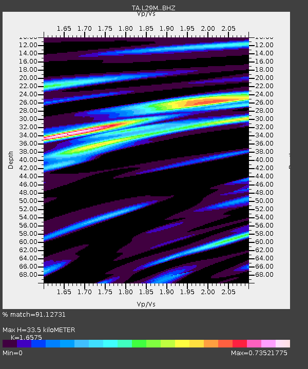
| Estimated Moho Depth: |
33.5 km |
| Estimated Crust Vp/Vs: |
1.66 |
| Assumed Crust Vp: |
6.566 km/s |
| Estimated Crust Vs: |
3.961 km/s |
| Estimated Crust Poisson's Ratio: |
0.21 |
|
| Radial Match: |
91.12731 % |
| Radial Bump: |
400 |
| Transverse Match: |
68.72727 % |
| Transverse Bump: |
400 |
| SOD ConfigId: |
21166931 |
| Insert Time: |
2020-05-26 23:00:39.148 +0000 |
| GWidth: |
2.5 |
| Max Bumps: |
400 |
| Tol: |
0.001 |
|
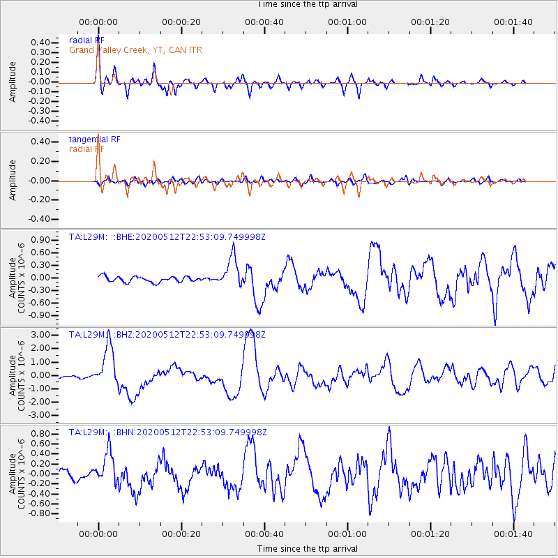
Signal To Noise
| Channel | StoN | STA | LTA |
| TA:L29M: :BHZ:20200512T22:53:09.749998Z | 24.144184 | 1.6310148E-6 | 6.755312E-8 |
| TA:L29M: :BHN:20200512T22:53:09.749998Z | 3.7303731 | 3.40644E-7 | 9.131633E-8 |
| TA:L29M: :BHE:20200512T22:53:09.749998Z | 5.7257085 | 3.8110664E-7 | 6.656061E-8 |
| Arrivals |
| Ps | 3.4 SECOND |
| PpPs | 13 SECOND |
| PsPs/PpSs | 17 SECOND |


