You are here: Home > Network List > TA - USArray Transportable Network (new EarthScope stations) Stations List
> Station M22K Willow, AK, USA > Earthquake Result Viewer
M22K Willow, AK, USA - Earthquake Result Viewer
| Earthquake location: |
Santa Cruz Islands |
| Earthquake latitude/longitude: |
-12.1/166.6 |
| Earthquake time(UTC): |
2020/05/12 (133) 22:41:12 GMT |
| Earthquake Depth: |
107 km |
| Earthquake Magnitude: |
6.6 mww |
| Earthquake Catalog/Contributor: |
NEIC PDE/us |
|
| Network: |
TA USArray Transportable Network (new EarthScope stations) |
| Station: |
M22K Willow, AK, USA |
| Lat/Lon: |
61.75 N/150.12 W |
| Elevation: |
57 m |
|
| Distance: |
81.0 deg |
| Az: |
19.264 deg |
| Baz: |
222.715 deg |
| Ray Param: |
0.047655832 |
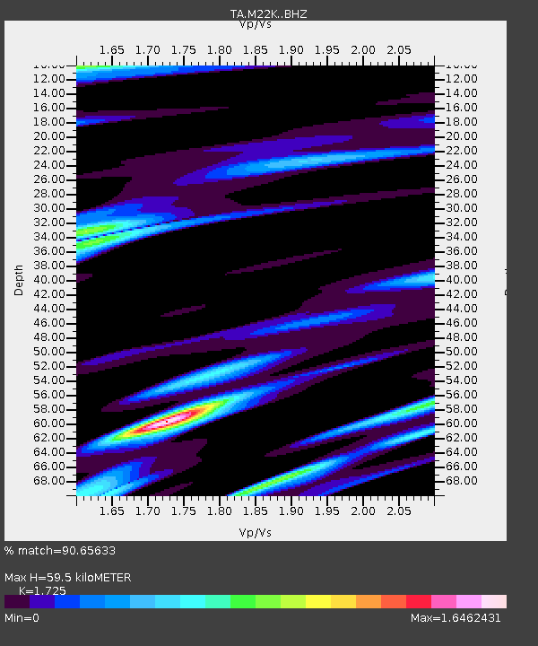
| Estimated Moho Depth: |
59.5 km |
| Estimated Crust Vp/Vs: |
1.73 |
| Assumed Crust Vp: |
6.302 km/s |
| Estimated Crust Vs: |
3.653 km/s |
| Estimated Crust Poisson's Ratio: |
0.25 |
|
| Radial Match: |
90.65633 % |
| Radial Bump: |
400 |
| Transverse Match: |
86.9468 % |
| Transverse Bump: |
400 |
| SOD ConfigId: |
21166931 |
| Insert Time: |
2020-05-26 23:00:50.369 +0000 |
| GWidth: |
2.5 |
| Max Bumps: |
400 |
| Tol: |
0.001 |
|
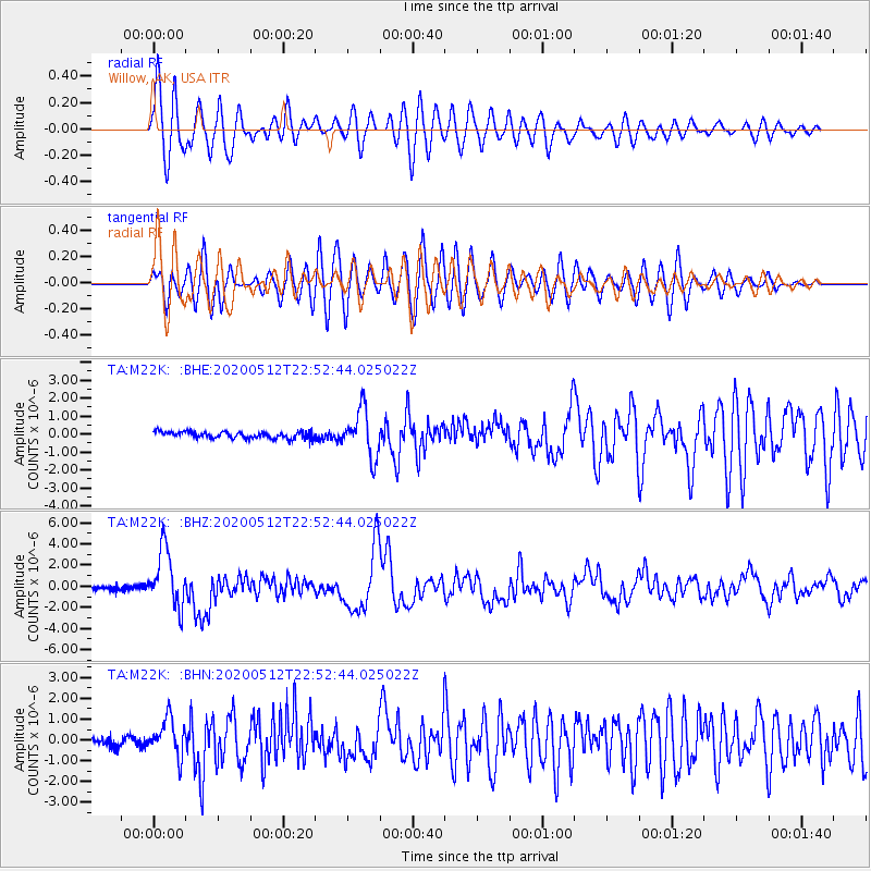
Signal To Noise
| Channel | StoN | STA | LTA |
| TA:M22K: :BHZ:20200512T22:52:44.025022Z | 19.121567 | 2.7061794E-6 | 1.4152498E-7 |
| TA:M22K: :BHN:20200512T22:52:44.025022Z | 4.378665 | 9.072106E-7 | 2.0718886E-7 |
| TA:M22K: :BHE:20200512T22:52:44.025022Z | 7.1344805 | 1.3021535E-6 | 1.8251554E-7 |
| Arrivals |
| Ps | 7.0 SECOND |
| PpPs | 25 SECOND |
| PsPs/PpSs | 32 SECOND |


