You are here: Home > Network List > IW - Intermountain West Stations List
> Station MOOW Moose Ponds, Wyoming, USA > Earthquake Result Viewer
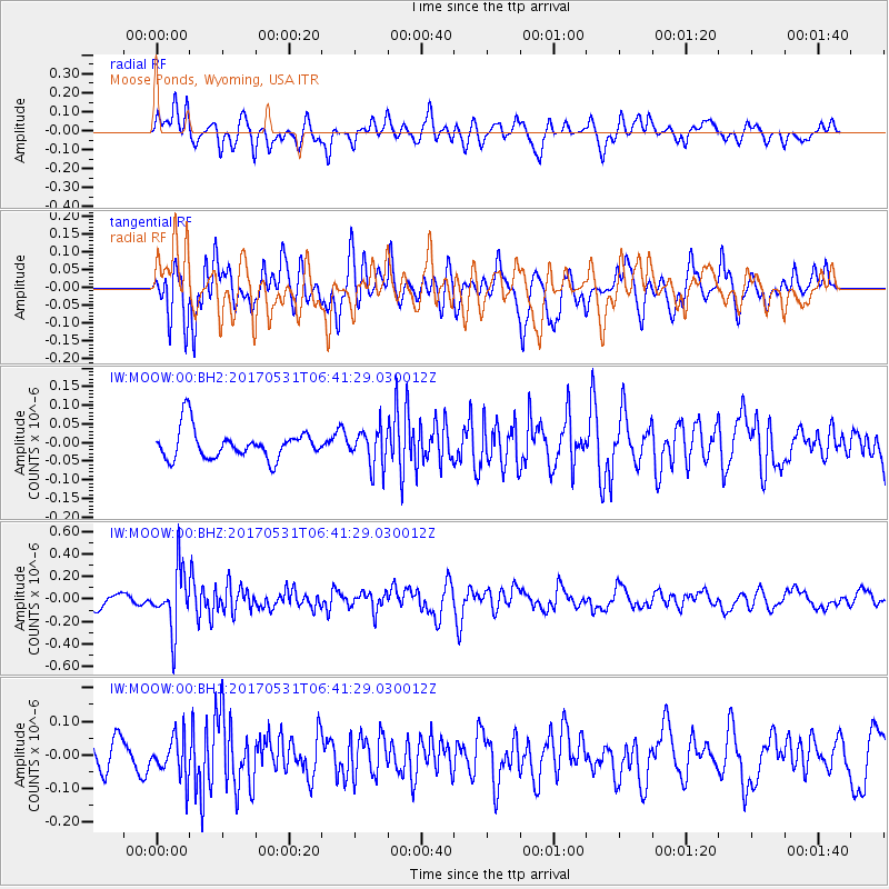
MOOW Moose Ponds, Wyoming, USA - Earthquake Result Viewer
*The percent match for this event was below the threshold and hence no stack was calculated.
| Earthquake location: |
Mariana Islands |
| Earthquake latitude/longitude: |
19.1/145.9 |
| Earthquake time(UTC): |
2017/05/31 (151) 06:29:32 GMT |
| Earthquake Depth: |
121 km |
| Earthquake Magnitude: |
5.4 Mww |
| Earthquake Catalog/Contributor: |
NEIC PDE/us |
|
| Network: |
IW Intermountain West |
| Station: |
MOOW Moose Ponds, Wyoming, USA |
| Lat/Lon: |
43.75 N/110.74 W |
| Elevation: |
2128 m |
|
| Distance: |
86.3 deg |
| Az: |
44.949 deg |
| Baz: |
292.799 deg |
| Ray Param: |
$rayparam |
*The percent match for this event was below the threshold and hence was not used in the summary stack. |
|
| Radial Match: |
54.001434 % |
| Radial Bump: |
400 |
| Transverse Match: |
64.73787 % |
| Transverse Bump: |
400 |
| SOD ConfigId: |
2140511 |
| Insert Time: |
2017-06-13 22:23:29.630 +0000 |
| GWidth: |
2.5 |
| Max Bumps: |
400 |
| Tol: |
0.001 |
|
Signal To Noise
| Channel | StoN | STA | LTA |
| IW:MOOW:00:BHZ:20170531T06:41:29.030012Z | 4.385536 | 2.6414668E-7 | 6.023133E-8 |
| IW:MOOW:00:BH1:20170531T06:41:29.030012Z | 1.115415 | 6.0985435E-8 | 5.467511E-8 |
| IW:MOOW:00:BH2:20170531T06:41:29.030012Z | 1.2533249 | 4.9789833E-8 | 3.97262E-8 |
| Arrivals |
| Ps | |
| PpPs | |
| PsPs/PpSs | |


