You are here: Home > Network List > UU - University of Utah Regional Network Stations List
> Station KNB Kanab, UT, USA > Earthquake Result Viewer
KNB Kanab, UT, USA - Earthquake Result Viewer
| Earthquake location: |
Santa Cruz Islands |
| Earthquake latitude/longitude: |
-12.1/166.6 |
| Earthquake time(UTC): |
2020/05/12 (133) 22:41:12 GMT |
| Earthquake Depth: |
107 km |
| Earthquake Magnitude: |
6.6 mww |
| Earthquake Catalog/Contributor: |
NEIC PDE/us |
|
| Network: |
UU University of Utah Regional Network |
| Station: |
KNB Kanab, UT, USA |
| Lat/Lon: |
37.02 N/112.82 W |
| Elevation: |
1715 m |
|
| Distance: |
89.8 deg |
| Az: |
52.139 deg |
| Baz: |
254.768 deg |
| Ray Param: |
0.04172423 |
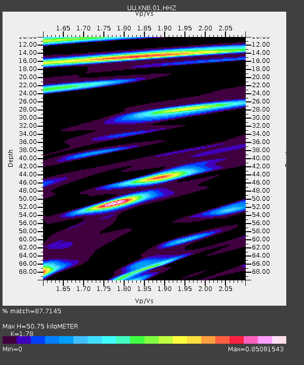
| Estimated Moho Depth: |
50.75 km |
| Estimated Crust Vp/Vs: |
1.78 |
| Assumed Crust Vp: |
6.194 km/s |
| Estimated Crust Vs: |
3.48 km/s |
| Estimated Crust Poisson's Ratio: |
0.27 |
|
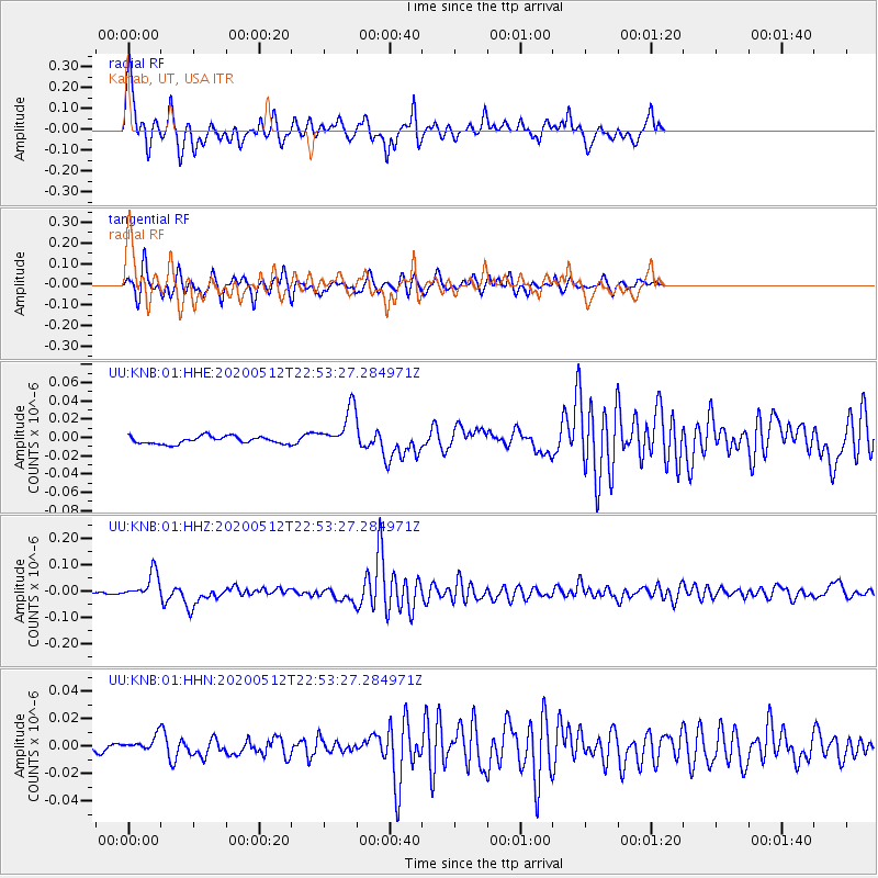
| Radial Match: |
87.7145 % |
| Radial Bump: |
397 |
| Transverse Match: |
88.86975 % |
| Transverse Bump: |
309 |
| SOD ConfigId: |
21166931 |
| Insert Time: |
2020-05-26 23:04:09.011 +0000 |
| GWidth: |
2.5 |
| Max Bumps: |
400 |
| Tol: |
0.001 |
|
Signal To Noise
| Channel | StoN | STA | LTA |
| UU:KNB:01:HHZ:20200512T22:53:27.284971Z | 22.169344 | 4.9087955E-8 | 2.2142268E-9 |
| UU:KNB:01:HHN:20200512T22:53:27.284971Z | 1.3455974 | 4.818925E-9 | 3.5812528E-9 |
| UU:KNB:01:HHE:20200512T22:53:27.284971Z | 5.5045733 | 2.2238146E-8 | 4.03994E-9 |
| Arrivals |
| Ps | 6.5 SECOND |
| PpPs | 22 SECOND |
| PsPs/PpSs | 29 SECOND |


