You are here: Home > Network List > UW - Pacific Northwest Regional Seismic Network Stations List
> Station LCCR Mulino, OR, USA > Earthquake Result Viewer
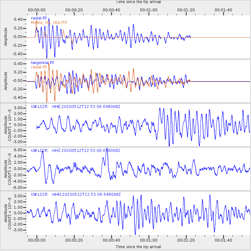
LCCR Mulino, OR, USA - Earthquake Result Viewer
*The percent match for this event was below the threshold and hence no stack was calculated.
| Earthquake location: |
Santa Cruz Islands |
| Earthquake latitude/longitude: |
-12.1/166.6 |
| Earthquake time(UTC): |
2020/05/12 (133) 22:41:12 GMT |
| Earthquake Depth: |
107 km |
| Earthquake Magnitude: |
6.6 mww |
| Earthquake Catalog/Contributor: |
NEIC PDE/us |
|
| Network: |
UW Pacific Northwest Regional Seismic Network |
| Station: |
LCCR Mulino, OR, USA |
| Lat/Lon: |
45.21 N/122.48 W |
| Elevation: |
273 m |
|
| Distance: |
85.4 deg |
| Az: |
42.071 deg |
| Baz: |
247.993 deg |
| Ray Param: |
$rayparam |
*The percent match for this event was below the threshold and hence was not used in the summary stack. |
|
| Radial Match: |
71.99318 % |
| Radial Bump: |
400 |
| Transverse Match: |
68.21172 % |
| Transverse Bump: |
400 |
| SOD ConfigId: |
21166931 |
| Insert Time: |
2020-05-26 23:05:12.724 +0000 |
| GWidth: |
2.5 |
| Max Bumps: |
400 |
| Tol: |
0.001 |
|
Signal To Noise
| Channel | StoN | STA | LTA |
| UW:LCCR: :HHZ:20200512T22:53:06.648008Z | 7.849449 | 2.6532023E-6 | 3.3801126E-7 |
| UW:LCCR: :HHN:20200512T22:53:06.648008Z | 1.1884837 | 5.66663E-7 | 4.7679495E-7 |
| UW:LCCR: :HHE:20200512T22:53:06.648008Z | 0.9173854 | 6.8827035E-7 | 7.502522E-7 |
| Arrivals |
| Ps | |
| PpPs | |
| PsPs/PpSs | |


