You are here: Home > Network List > UW - Pacific Northwest Regional Seismic Network Stations List
> Station UMAT Pilot Rock, OR, USA > Earthquake Result Viewer
UMAT Pilot Rock, OR, USA - Earthquake Result Viewer

| Earthquake location: |
Santa Cruz Islands |
| Earthquake latitude/longitude: |
-12.1/166.6 |
| Earthquake time(UTC): |
2020/05/12 (133) 22:41:12 GMT |
| Earthquake Depth: |
107 km |
| Earthquake Magnitude: |
6.6 mww |
| Earthquake Catalog/Contributor: |
NEIC PDE/us |
|
| Network: |
UW Pacific Northwest Regional Seismic Network |
| Station: |
UMAT Pilot Rock, OR, USA |
| Lat/Lon: |
45.29 N/118.96 W |
| Elevation: |
1318 m |
|
| Distance: |
87.8 deg |
| Az: |
42.873 deg |
| Baz: |
250.532 deg |
| Ray Param: |
0.042847667 |
| Estimated Moho Depth: |
35.5 km |
| Estimated Crust Vp/Vs: |
1.80 |
| Assumed Crust Vp: |
6.571 km/s |
| Estimated Crust Vs: |
3.645 km/s |
| Estimated Crust Poisson's Ratio: |
0.28 |
|
| Radial Match: |
92.33918 % |
| Radial Bump: |
247 |
| Transverse Match: |
68.809456 % |
| Transverse Bump: |
350 |
| SOD ConfigId: |
21166931 |
| Insert Time: |
2020-05-26 23:05:53.943 +0000 |
| GWidth: |
2.5 |
| Max Bumps: |
400 |
| Tol: |
0.001 |
|
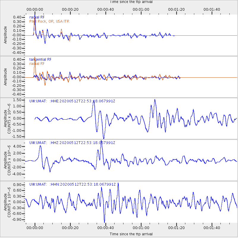
Signal To Noise
| Channel | StoN | STA | LTA |
| UW:UMAT: :HHZ:20200512T22:53:18.067991Z | 13.631917 | 1.9948711E-6 | 1.4633828E-7 |
| UW:UMAT: :HHN:20200512T22:53:18.067991Z | 1.8378944 | 1.8747582E-7 | 1.02005764E-7 |
| UW:UMAT: :HHE:20200512T22:53:18.067991Z | 8.36866 | 6.8234857E-7 | 8.1536186E-8 |
| Arrivals |
| Ps | 4.4 SECOND |
| PpPs | 15 SECOND |
| PsPs/PpSs | 19 SECOND |


