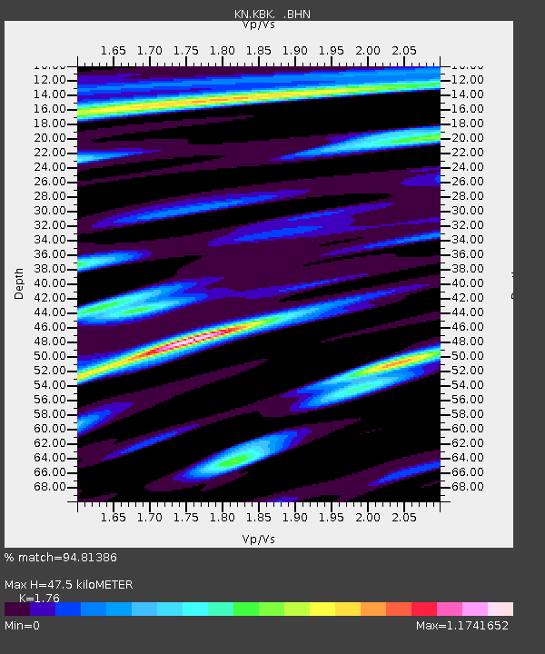
KBK KN.KBK - Earthquake Result Viewer
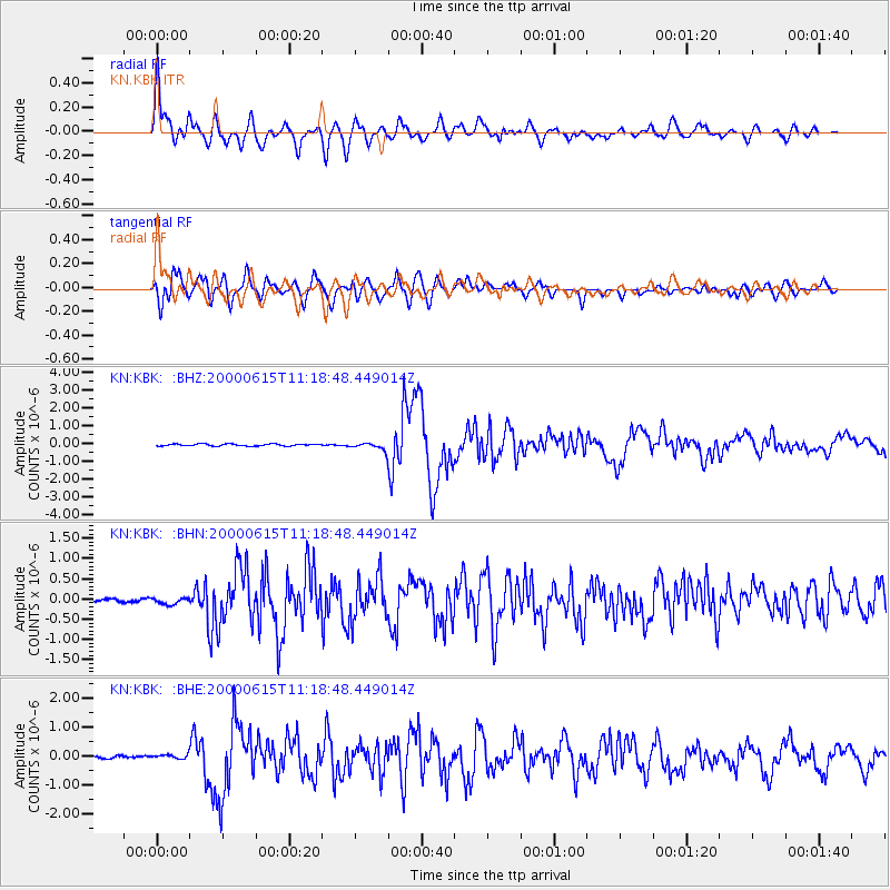
Earthquake location: Southeast Of Shikoku, Japan
Earthquake latitude/longitude: 29.4/132.1
Earthquake time(UTC): 2000/06/15 (167) 11:10:46 GMT
Earthquake Depth: 10 km
Earthquake Magnitude: 6.0 MB, 5.6 MS, 6.1 MW, 6.1 MW
Earthquake Catalog/Contributor: WHDF/NEIC
Network: KN Kyrgyz Seismic Telemetry Network
Station: KBK KN.KBK
Lat/Lon: 42.66 N/74.95 E
Elevation: 1760 m
Distance: 47.2 deg
Az: 302.451 deg
Baz: 86.867 deg
Ray Param: 0.07011768
Estimated Moho Depth: 47.5 km
Estimated Crust Vp/Vs: 1.76
Assumed Crust Vp: 6.306 km/s
Estimated Crust Vs: 3.583 km/s
Estimated Crust Poisson's Ratio: 0.26
Radial Match: 94.81386 %
Radial Bump: 400
Transverse Match: 90.070145 %
Transverse Bump: 400
SOD ConfigId: 3744
Insert Time: 2010-03-08 20:03:56.541 +0000
GWidth: 2.5
Max Bumps: 400
Tol: 0.001

Signal To Noise

ChannelStoNSTALTA
KN:KBK: :BHN:20000615T11:18:48.449014Z1.30368758.0169876E-86.14947E-8
KN:KBK: :BHE:20000615T11:18:48.449014Z1.44585476.4982395E-84.494393E-8
KN:KBK: :BHZ:20000615T11:18:48.449014Z3.84611232.1246277E-75.5240918E-8
Arrivals
Ps6.1 SECOND
PpPs20 SECOND
PsPs/PpSs26 SECOND