You are here: Home > Network List > US - United States National Seismic Network Stations List
> Station EGMT Eagleton, Montana, USA > Earthquake Result Viewer
EGMT Eagleton, Montana, USA - Earthquake Result Viewer
*The percent match for this event was below the threshold and hence no stack was calculated.
| Earthquake location: |
Mariana Islands |
| Earthquake latitude/longitude: |
19.1/145.9 |
| Earthquake time(UTC): |
2017/05/31 (151) 06:29:32 GMT |
| Earthquake Depth: |
121 km |
| Earthquake Magnitude: |
5.4 Mww |
| Earthquake Catalog/Contributor: |
NEIC PDE/us |
|
| Network: |
US United States National Seismic Network |
| Station: |
EGMT Eagleton, Montana, USA |
| Lat/Lon: |
48.02 N/109.75 W |
| Elevation: |
1055 m |
|
| Distance: |
85.2 deg |
| Az: |
40.731 deg |
| Baz: |
293.195 deg |
| Ray Param: |
$rayparam |
*The percent match for this event was below the threshold and hence was not used in the summary stack. |
|
| Radial Match: |
40.907196 % |
| Radial Bump: |
400 |
| Transverse Match: |
44.317764 % |
| Transverse Bump: |
400 |
| SOD ConfigId: |
2140511 |
| Insert Time: |
2017-06-13 22:24:45.322 +0000 |
| GWidth: |
2.5 |
| Max Bumps: |
400 |
| Tol: |
0.001 |
|
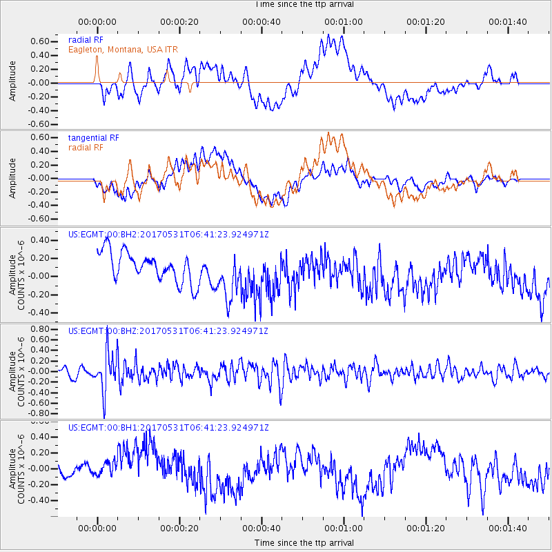
Signal To Noise
| Channel | StoN | STA | LTA |
| US:EGMT:00:BHZ:20170531T06:41:23.924971Z | 4.85464 | 3.714357E-7 | 7.651149E-8 |
| US:EGMT:00:BH1:20170531T06:41:23.924971Z | 1.7449824 | 1.9097227E-7 | 1.09440805E-7 |
| US:EGMT:00:BH2:20170531T06:41:23.924971Z | 1.6883792 | 2.7231752E-7 | 1.6128932E-7 |
| Arrivals |
| Ps | |
| PpPs | |
| PsPs/PpSs | |


