KBK KN.KBK - Earthquake Result Viewer
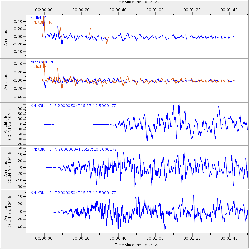
Earthquake location: Southern Sumatra, Indonesia
Earthquake latitude/longitude: -4.7/102.1
Earthquake time(UTC): 2000/06/04 (156) 16:28:26 GMT
Earthquake Depth: 33 km
Earthquake Magnitude: 6.8 MB, 8.0 MS, 7.9 MW, 7.7 MW
Earthquake Catalog/Contributor: WHDF/NEIC
Network: KN Kyrgyz Seismic Telemetry Network
Station: KBK KN.KBK
Lat/Lon: 42.66 N/74.95 E
Elevation: 1760 m
Distance: 53.2 deg
Az: 335.149 deg
Baz: 145.403 deg
Ray Param: 0.066199385
Estimated Moho Depth: 17.75 km
Estimated Crust Vp/Vs: 1.80
Assumed Crust Vp: 6.306 km/s
Estimated Crust Vs: 3.503 km/s
Estimated Crust Poisson's Ratio: 0.28
Radial Match: 94.28827 %
Radial Bump: 400
Transverse Match: 92.2209 %
Transverse Bump: 400
SOD ConfigId: 3744
Insert Time: 2010-03-08 20:04:30.088 +0000
GWidth: 2.5
Max Bumps: 400
Tol: 0.001

Signal To Noise

ChannelStoNSTALTA
KN:KBK: :BHN:20000604T16:37:10.500017Z4.97617674.253646E-78.5480195E-8
KN:KBK: :BHE:20000604T16:37:10.500017Z3.20072772.1457475E-76.7039366E-8
KN:KBK: :BHZ:20000604T16:37:10.500017Z3.51937157.2764175E-72.0675331E-7
Arrivals
Ps2.4 SECOND
PpPs7.5 SECOND
PsPs/PpSs9.9 SECOND