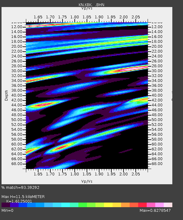
KBK KN.KBK - Earthquake Result Viewer

Earthquake location: Banda Sea
Earthquake latitude/longitude: -4.3/123.2
Earthquake time(UTC): 2000/05/14 (135) 20:08:34 GMT
Earthquake Depth: 33 km
Earthquake Magnitude: 5.9 MB, 5.9 MS, 6.3 MW, 6.2 MW
Earthquake Catalog/Contributor: WHDF/NEIC
Network: KN Kyrgyz Seismic Telemetry Network
Station: KBK KN.KBK
Lat/Lon: 42.66 N/74.95 E
Elevation: 1760 m
Distance: 63.9 deg
Az: 322.227 deg
Baz: 124.103 deg
Ray Param: 0.059220176
Estimated Moho Depth: 11.5 km
Estimated Crust Vp/Vs: 1.61
Assumed Crust Vp: 6.306 km/s
Estimated Crust Vs: 3.911 km/s
Estimated Crust Poisson's Ratio: 0.19
Radial Match: 93.39292 %
Radial Bump: 400
Transverse Match: 91.83666 %
Transverse Bump: 400
SOD ConfigId: 3744
Insert Time: 2010-03-08 20:04:33.894 +0000
GWidth: 2.5
Max Bumps: 400
Tol: 0.001

Signal To Noise

ChannelStoNSTALTA
KN:KBK: :BHN:20000514T20:18:33.073999Z3.96891571.3991256E-73.5252086E-8
KN:KBK: :BHE:20000514T20:18:33.073999Z4.7933962.3671335E-74.9383225E-8
KN:KBK: :BHZ:20000514T20:18:33.073999Z25.0887268.795921E-73.505926E-8
Arrivals
Ps1.2 SECOND
PpPs4.6 SECOND
PsPs/PpSs5.7 SECOND