You are here: Home > Network List > US - United States National Seismic Network Stations List
> Station LKWY Lake (Yellowstone--Lake), Wyoming, USA > Earthquake Result Viewer
LKWY Lake (Yellowstone--Lake), Wyoming, USA - Earthquake Result Viewer
*The percent match for this event was below the threshold and hence no stack was calculated.
| Earthquake location: |
Mariana Islands |
| Earthquake latitude/longitude: |
19.1/145.9 |
| Earthquake time(UTC): |
2017/05/31 (151) 06:29:32 GMT |
| Earthquake Depth: |
121 km |
| Earthquake Magnitude: |
5.4 Mww |
| Earthquake Catalog/Contributor: |
NEIC PDE/us |
|
| Network: |
US United States National Seismic Network |
| Station: |
LKWY Lake (Yellowstone--Lake), Wyoming, USA |
| Lat/Lon: |
44.57 N/110.40 W |
| Elevation: |
2424 m |
|
| Distance: |
86.2 deg |
| Az: |
44.098 deg |
| Baz: |
292.983 deg |
| Ray Param: |
$rayparam |
*The percent match for this event was below the threshold and hence was not used in the summary stack. |
|
| Radial Match: |
85.3543 % |
| Radial Bump: |
400 |
| Transverse Match: |
82.635925 % |
| Transverse Bump: |
400 |
| SOD ConfigId: |
2140511 |
| Insert Time: |
2017-06-13 22:24:56.966 +0000 |
| GWidth: |
2.5 |
| Max Bumps: |
400 |
| Tol: |
0.001 |
|
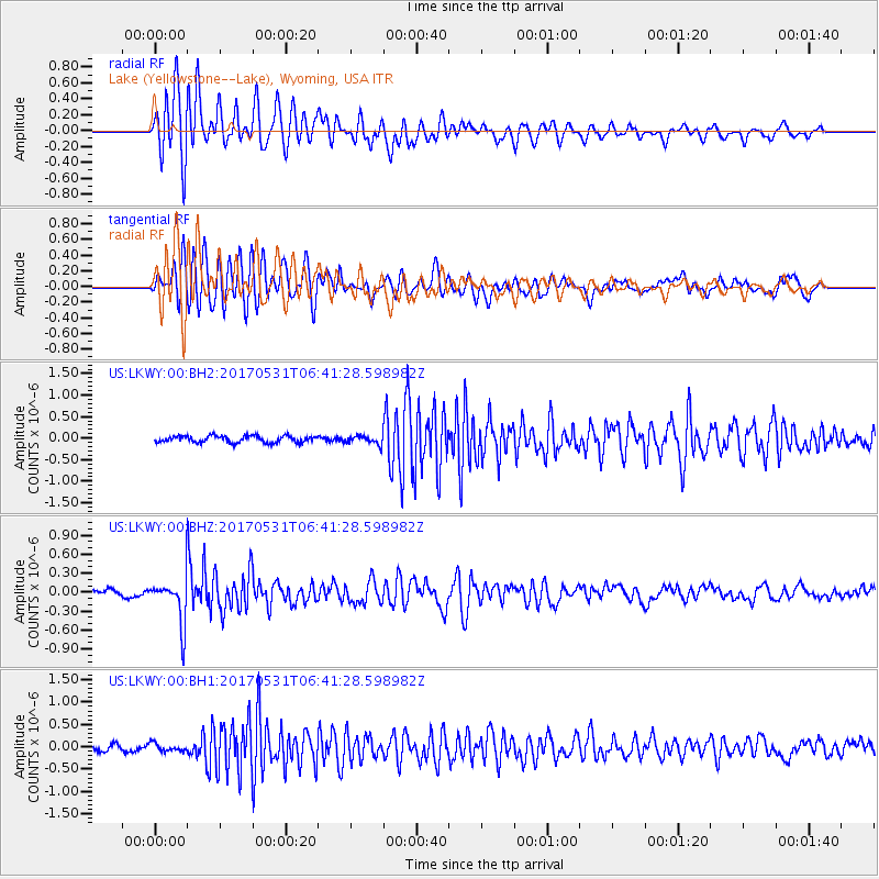
Signal To Noise
| Channel | StoN | STA | LTA |
| US:LKWY:00:BHZ:20170531T06:41:28.598982Z | 4.0547976 | 3.550776E-7 | 8.756974E-8 |
| US:LKWY:00:BH1:20170531T06:41:28.598982Z | 1.027073 | 8.754742E-8 | 8.523972E-8 |
| US:LKWY:00:BH2:20170531T06:41:28.598982Z | 1.2601846 | 9.804212E-8 | 7.779981E-8 |
| Arrivals |
| Ps | |
| PpPs | |
| PsPs/PpSs | |


