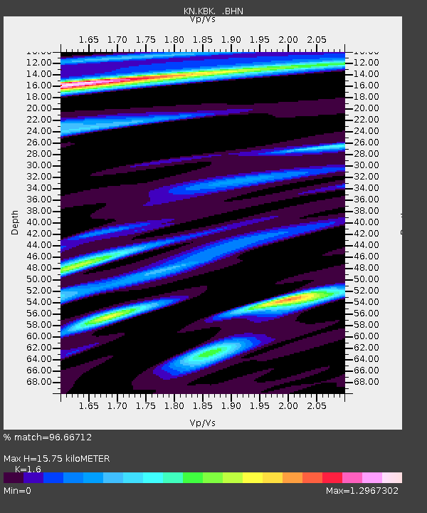
KBK KN.KBK - Earthquake Result Viewer

Earthquake location: Volcano Islands, Japan Region
Earthquake latitude/longitude: 22.3/143.7
Earthquake time(UTC): 2000/03/28 (088) 11:00:22 GMT
Earthquake Depth: 126 km
Earthquake Magnitude: 6.8 MB, 7.6 MS, 7.6 MW, 7.6 MW
Earthquake Catalog/Contributor: WHDF/NEIC
Network: KN Kyrgyz Seismic Telemetry Network
Station: KBK KN.KBK
Lat/Lon: 42.66 N/74.95 E
Elevation: 1760 m
Distance: 59.8 deg
Az: 307.316 deg
Baz: 86.516 deg
Ray Param: 0.061541665
Estimated Moho Depth: 15.75 km
Estimated Crust Vp/Vs: 1.60
Assumed Crust Vp: 6.306 km/s
Estimated Crust Vs: 3.941 km/s
Estimated Crust Poisson's Ratio: 0.18
Radial Match: 96.66712 %
Radial Bump: 400
Transverse Match: 92.96388 %
Transverse Bump: 400
SOD ConfigId: 3744
Insert Time: 2010-03-08 20:04:55.757 +0000
GWidth: 2.5
Max Bumps: 400
Tol: 0.001

Signal To Noise

ChannelStoNSTALTA
KN:KBK: :BHN:20000328T11:09:44.025015Z1.2033079.670744E-88.0368046E-8
KN:KBK: :BHE:20000328T11:09:44.025015Z4.72223333.661191E-77.753093E-8
KN:KBK: :BHZ:20000328T11:09:44.025015Z4.87502969.075635E-71.8616575E-7
Arrivals
Ps1.6 SECOND
PpPs6.2 SECOND
PsPs/PpSs7.8 SECOND