You are here: Home > Network List > CU - Caribbean Network (USGS) Stations List
> Station MTDJ Mount Denham, Jamaica > Earthquake Result Viewer
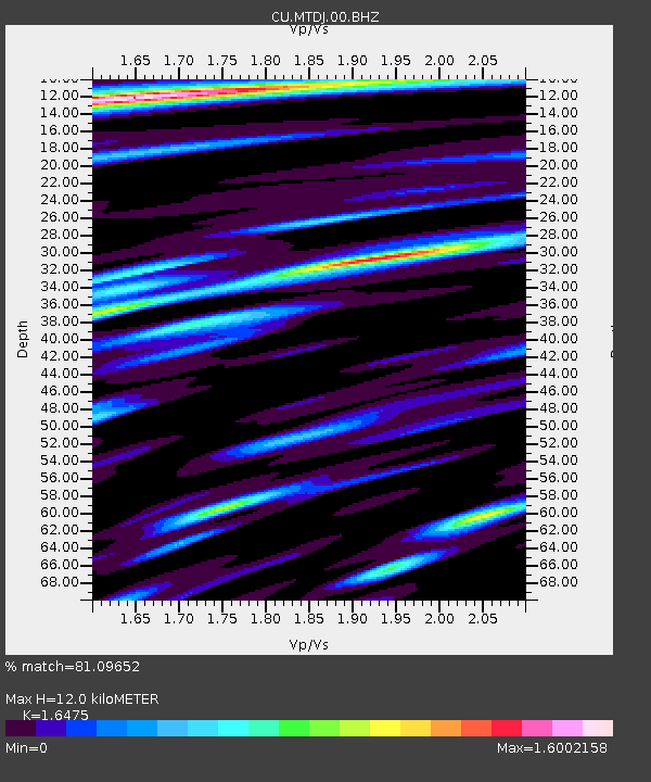
MTDJ Mount Denham, Jamaica - Earthquake Result Viewer
| Earthquake location: |
Nevada |
| Earthquake latitude/longitude: |
38.2/-117.9 |
| Earthquake time(UTC): |
2020/05/15 (136) 11:03:26 GMT |
| Earthquake Depth: |
0.4 km |
| Earthquake Magnitude: |
6.5 Mww |
| Earthquake Catalog/Contributor: |
NEIC PDE/nn |
|
| Network: |
CU Caribbean Network (USGS) |
| Station: |
MTDJ Mount Denham, Jamaica |
| Lat/Lon: |
18.23 N/77.53 W |
| Elevation: |
925 m |
|
| Distance: |
40.3 deg |
| Az: |
108.059 deg |
| Baz: |
307.952 deg |
| Ray Param: |
0.074486196 |
| Estimated Moho Depth: |
12.0 km |
| Estimated Crust Vp/Vs: |
1.65 |
| Assumed Crust Vp: |
4.662 km/s |
| Estimated Crust Vs: |
2.83 km/s |
| Estimated Crust Poisson's Ratio: |
0.21 |
|
| Radial Match: |
81.09652 % |
| Radial Bump: |
400 |
| Transverse Match: |
67.812355 % |
| Transverse Bump: |
400 |
| SOD ConfigId: |
21166931 |
| Insert Time: |
2020-05-29 11:08:11.356 +0000 |
| GWidth: |
2.5 |
| Max Bumps: |
400 |
| Tol: |
0.001 |
|

Signal To Noise
| Channel | StoN | STA | LTA |
| CU:MTDJ:00:BHZ:20200515T11:10:34.874001Z | 1.9632406 | 5.389177E-7 | 2.7450415E-7 |
| CU:MTDJ:00:BH1:20200515T11:10:34.874001Z | 1.2282645 | 3.3087505E-7 | 2.693842E-7 |
| CU:MTDJ:00:BH2:20200515T11:10:34.874001Z | 1.4602098 | 4.4148277E-7 | 3.02342E-7 |
| Arrivals |
| Ps | 1.7 SECOND |
| PpPs | 6.6 SECOND |
| PsPs/PpSs | 8.3 SECOND |


