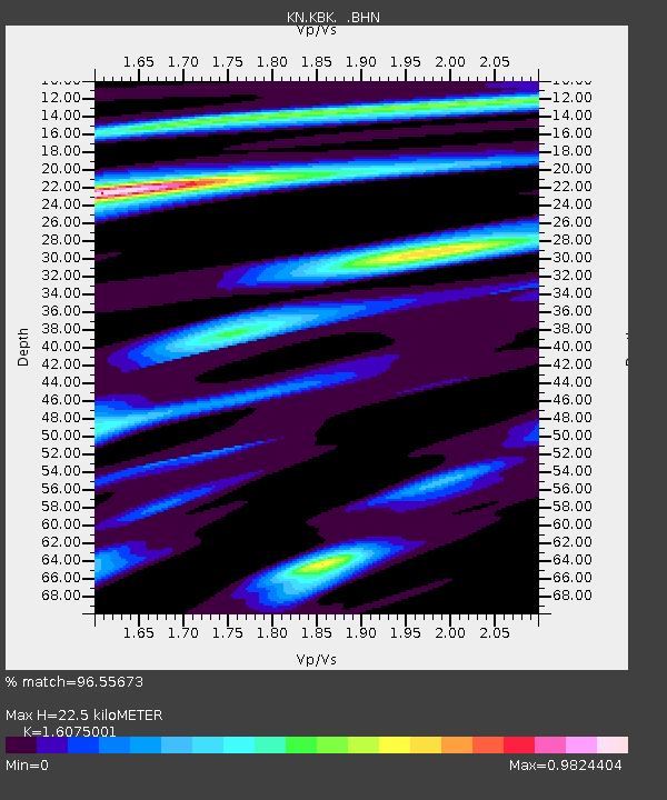
KBK KN.KBK - Earthquake Result Viewer
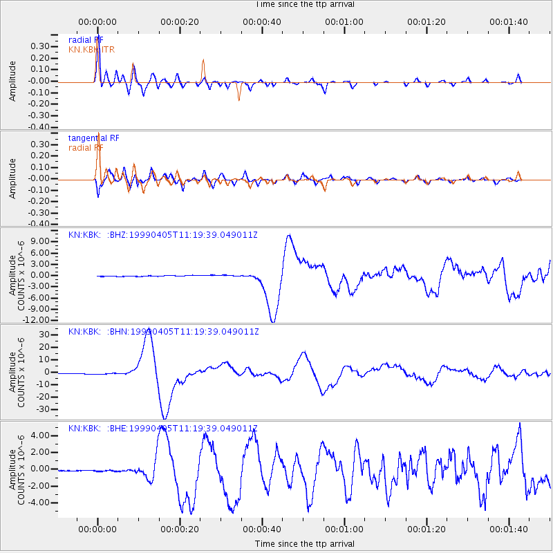
Earthquake location: New Britain Region, P.N.G.
Earthquake latitude/longitude: -5.6/149.6
Earthquake time(UTC): 1999/04/05 (095) 11:08:04 GMT
Earthquake Depth: 150 km
Earthquake Magnitude: 6.2 MB, 7.0 MS, 7.4 MW, 7.3 ME
Earthquake Catalog/Contributor: WHDF/NEIC
Network: KN Kyrgyz Seismic Telemetry Network
Station: KBK KN.KBK
Lat/Lon: 42.66 N/74.95 E
Elevation: 1760 m
Distance: 82.6 deg
Az: 314.167 deg
Baz: 104.58 deg
Ray Param: 0.046451613
Estimated Moho Depth: 22.5 km
Estimated Crust Vp/Vs: 1.61
Assumed Crust Vp: 6.306 km/s
Estimated Crust Vs: 3.923 km/s
Estimated Crust Poisson's Ratio: 0.18
Radial Match: 96.55673 %
Radial Bump: 400
Transverse Match: 93.6701 %
Transverse Bump: 400
SOD ConfigId: 4480
Insert Time: 2010-03-08 20:05:13.235 +0000
GWidth: 2.5
Max Bumps: 400
Tol: 0.001

Signal To Noise

ChannelStoNSTALTA
KN:KBK: :BHN:19990405T11:19:39.049011Z2.07369043.8771222E-71.8696726E-7
KN:KBK: :BHE:19990405T11:19:39.049011Z1.39018645.8432736E-84.20323E-8
KN:KBK: :BHZ:19990405T11:19:39.049011Z1.52448621.7552229E-71.1513537E-7
Arrivals
Ps2.2 SECOND
PpPs9.1 SECOND
PsPs/PpSs11 SECOND