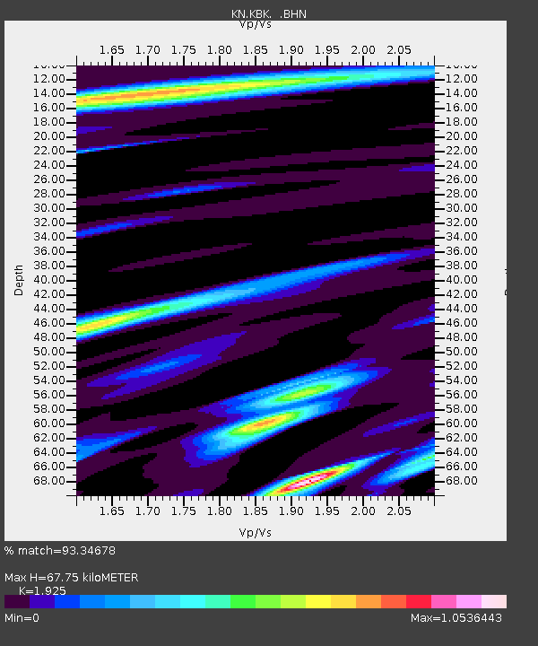
KBK KN.KBK - Earthquake Result Viewer
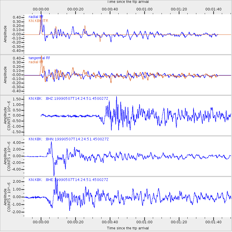
Earthquake location: Kodiak Island Region, Alaska
Earthquake latitude/longitude: 56.4/-152.9
Earthquake time(UTC): 1999/05/07 (127) 14:13:52 GMT
Earthquake Depth: 20 km
Earthquake Magnitude: 5.7 MB, 6.1 MS, 6.4 MW, 5.7 ME
Earthquake Catalog/Contributor: WHDF/NEIC
Network: KN Kyrgyz Seismic Telemetry Network
Station: KBK KN.KBK
Lat/Lon: 42.66 N/74.95 E
Elevation: 1760 m
Distance: 73.4 deg
Az: 325.169 deg
Baz: 25.485 deg
Ray Param: 0.053036466
Estimated Moho Depth: 67.75 km
Estimated Crust Vp/Vs: 1.92
Assumed Crust Vp: 6.306 km/s
Estimated Crust Vs: 3.276 km/s
Estimated Crust Poisson's Ratio: 0.32
Radial Match: 93.34678 %
Radial Bump: 400
Transverse Match: 89.28738 %
Transverse Bump: 400
SOD ConfigId: 4480
Insert Time: 2010-03-08 20:05:16.824 +0000
GWidth: 2.5
Max Bumps: 400
Tol: 0.001

Signal To Noise

ChannelStoNSTALTA
KN:KBK: :BHN:19990507T14:24:51.450027Z16.2110317.049686E-74.3486967E-8
KN:KBK: :BHE:19990507T14:24:51.450027Z4.20310742.2423333E-75.3349417E-8
KN:KBK: :BHZ:19990507T14:24:51.450027Z2.21597171.0460298E-74.7204114E-8
Arrivals
Ps10 SECOND
PpPs30 SECOND
PsPs/PpSs41 SECOND