You are here: Home > Network List > LD - Lamont-Doherty Cooperative Seismographic Network Stations List
> Station GEDE Greenville, DE, USA > Earthquake Result Viewer
GEDE Greenville, DE, USA - Earthquake Result Viewer
| Earthquake location: |
Nevada |
| Earthquake latitude/longitude: |
38.2/-117.9 |
| Earthquake time(UTC): |
2020/05/15 (136) 11:03:26 GMT |
| Earthquake Depth: |
0.4 km |
| Earthquake Magnitude: |
6.5 Mww |
| Earthquake Catalog/Contributor: |
NEIC PDE/nn |
|
| Network: |
LD Lamont-Doherty Cooperative Seismographic Network |
| Station: |
GEDE Greenville, DE, USA |
| Lat/Lon: |
39.81 N/75.64 W |
| Elevation: |
105 m |
|
| Distance: |
32.7 deg |
| Az: |
73.657 deg |
| Baz: |
280.875 deg |
| Ray Param: |
0.07858534 |
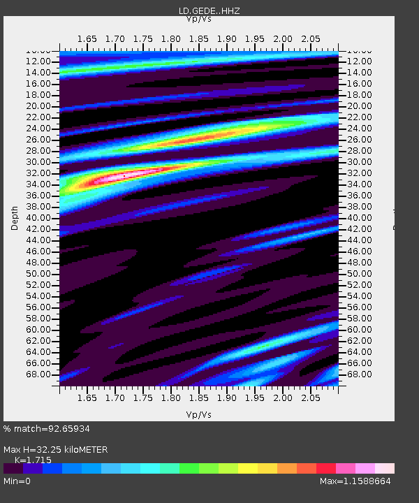
| Estimated Moho Depth: |
32.25 km |
| Estimated Crust Vp/Vs: |
1.72 |
| Assumed Crust Vp: |
6.287 km/s |
| Estimated Crust Vs: |
3.666 km/s |
| Estimated Crust Poisson's Ratio: |
0.24 |
|
| Radial Match: |
92.65934 % |
| Radial Bump: |
198 |
| Transverse Match: |
70.953476 % |
| Transverse Bump: |
393 |
| SOD ConfigId: |
21166931 |
| Insert Time: |
2020-05-29 11:11:15.448 +0000 |
| GWidth: |
2.5 |
| Max Bumps: |
400 |
| Tol: |
0.001 |
|

Signal To Noise
| Channel | StoN | STA | LTA |
| LD:GEDE: :HHZ:20200515T11:09:29.549996Z | 3.7149444 | 5.177784E-7 | 1.3937716E-7 |
| LD:GEDE: :HHN:20200515T11:09:29.549996Z | 0.70250034 | 9.186376E-8 | 1.3076686E-7 |
| LD:GEDE: :HHE:20200515T11:09:29.549996Z | 2.3175368 | 2.8478684E-7 | 1.2288342E-7 |
| Arrivals |
| Ps | 4.0 SECOND |
| PpPs | 13 SECOND |
| PsPs/PpSs | 17 SECOND |


