You are here: Home > Network List > NE - New England Seismic Network Stations List
> Station WSPT Westport, CT, USA > Earthquake Result Viewer
WSPT Westport, CT, USA - Earthquake Result Viewer
| Earthquake location: |
Nevada |
| Earthquake latitude/longitude: |
38.2/-117.9 |
| Earthquake time(UTC): |
2020/05/15 (136) 11:03:26 GMT |
| Earthquake Depth: |
0.4 km |
| Earthquake Magnitude: |
6.5 Mww |
| Earthquake Catalog/Contributor: |
NEIC PDE/nn |
|
| Network: |
NE New England Seismic Network |
| Station: |
WSPT Westport, CT, USA |
| Lat/Lon: |
41.17 N/73.33 W |
| Elevation: |
91 m |
|
| Distance: |
34.1 deg |
| Az: |
70.654 deg |
| Baz: |
279.862 deg |
| Ray Param: |
0.077909075 |
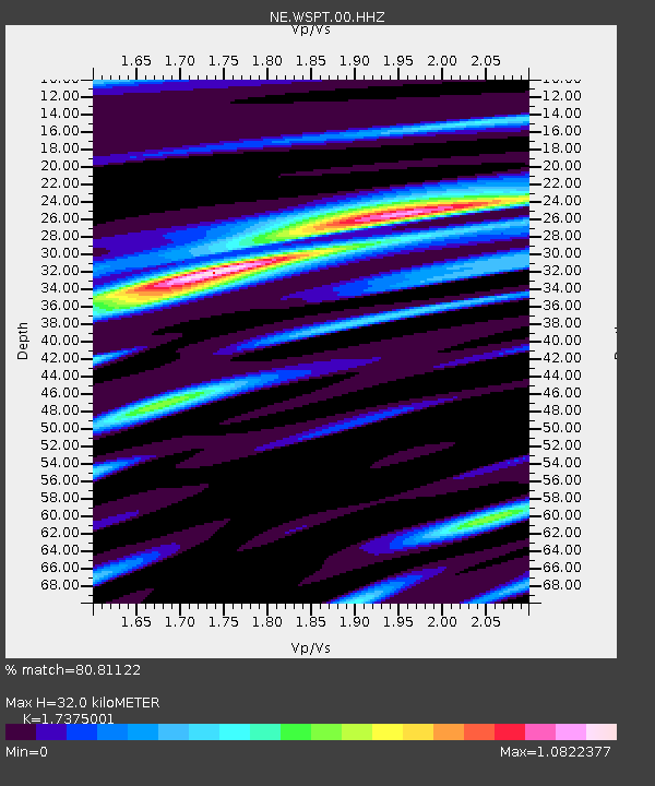
| Estimated Moho Depth: |
32.0 km |
| Estimated Crust Vp/Vs: |
1.74 |
| Assumed Crust Vp: |
6.472 km/s |
| Estimated Crust Vs: |
3.725 km/s |
| Estimated Crust Poisson's Ratio: |
0.25 |
|
| Radial Match: |
80.81122 % |
| Radial Bump: |
400 |
| Transverse Match: |
67.67758 % |
| Transverse Bump: |
400 |
| SOD ConfigId: |
21166931 |
| Insert Time: |
2020-05-29 11:12:48.688 +0000 |
| GWidth: |
2.5 |
| Max Bumps: |
400 |
| Tol: |
0.001 |
|

Signal To Noise
| Channel | StoN | STA | LTA |
| NE:WSPT:00:HHZ:20200515T11:09:42.483987Z | 2.673807 | 4.797292E-7 | 1.7941802E-7 |
| NE:WSPT:00:HH1:20200515T11:09:42.483987Z | 0.88617116 | 1.4221666E-7 | 1.604844E-7 |
| NE:WSPT:00:HH2:20200515T11:09:42.483987Z | 1.5666498 | 2.5049687E-7 | 1.5989335E-7 |
| Arrivals |
| Ps | 4.0 SECOND |
| PpPs | 12 SECOND |
| PsPs/PpSs | 16 SECOND |


